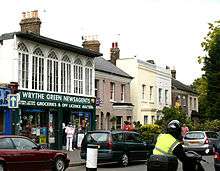
The Wrythe

The Wrythe is an area inside the London Borough of Sutton. The area is often referred to as Wrythe Green. The Wrythe is also a ward of Sutton Council with a population at the 2011 Census of 10,163.[1]
History
The Wrythe area's history dates back to the Roman era. The Place-names of Surrey says that the name may come from Anglo-Saxon rið = 'streamlet' (a small branch of the River Wandle). The population of the town is 10,384 residents.[2]
Facilities
The Wrythe, even though part of Carshalton, has its own commercial shopping area which has a number of different restaurants and shops, punctuated at either end with a Marks & Spencer Simply Food and the biggest branch of Nisa for thirty miles.[3] There are three primary schools in The Wrythe - Victor Seymour Infants School, Camden Junior School, Muschamp and Rushy Meadow Primary School - as well as Carshalton College.[2] aa
Transport links
From the Nisa store, The Wrythe is about eight minutes away from Carshalton railway station.[4] The 151 goes straight the way through it[5] whereas the 157 serves the M&S branch[6] and the 127 serves the college.[7]
References
- ↑ "Sutton Ward population 2011". Neighbourhood Statistics. Office for National Statistics. Retrieved 9 October 2016.
- 1 2 "The Wrythe". London Borough of Sutton. Archived from the original on 9 November 2013. Retrieved 9 November 2013.
- ↑ "Store Locator (type in the store's postcode, SM5 2DS)". Nisa-Today's. Retrieved 9 November 2013.
- ↑ "Scott's of Carshalton to Tyrell Ct". Google Maps. Retrieved 9 November 2013.
- ↑ "Bus map for route 151". Transport for London. Retrieved 9 November 2013.
- ↑ "Bus map for route 157". Transport for London. Retrieved 9 November 2013.
- ↑ "Bus map for route 127". Transport for London. Retrieved 9 November 2013.
Coordinates: 51°22′27″N 0°9′56″W / 51.37417°N 0.16556°W