String Lake Trail
| String Lake Trail | |
|---|---|
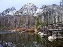
|
Footbridge across String Lake | |
| Length | 3.7 mi (6 km) |
| Location | Teton Range |
| Trailheads | String Lake Trailhead |
| Use | Hiking |
| Elevation | |
| Elevation change | Approximate gain of 550 ft (170 m) |
| Highest point | Near Paintbrush Canyon, 7,300 ft (2,200 m) |
| Lowest point | String Lake Trailhead, 6,880 ft (2,100 m) |
| Hiking details | |
| Trail difficulty | Easy |
| Season | Late Spring to Fall |
| Sights | Teton Range |
| Hazards | Severe weather |
The String Lake Trail is a 3.7-mile (6.0 km) long hiking trail in Grand Teton National Park in the U.S. state of Wyoming.[1] The trail circles String Lake and is also used to access the Paintbrush Canyon Trail and the Leigh Lake Trail.[2] The String Lake trailhead is off the one-way road from North Jenny Lake Junction.[3]
Coordinates: 43°47′20″N 110°44′13″W / 43.7888225°N 110.7368792°W[4]
See also
References
- ↑ Jenny Lake, WY (Map). Topoquest (USGS Quads). Retrieved 2012-05-20.
- ↑ "Day Hikes" (pdf). National Park Service. February 2012. Retrieved 2012-05-20.
- ↑ "String Lake Trailhead" (pdf). National Park Service. Retrieved 2012-05-20.
- ↑ "String Lake Trail". Geographic Names Information System. United States Geological Survey. Retrieved 2012-05-20.
This article is issued from Wikipedia - version of the 7/15/2013. The text is available under the Creative Commons Attribution/Share Alike but additional terms may apply for the media files.