Stollgraben
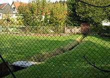 | |
| The Flösse in the village | |
| Location | Lower Harz, Straßberg |
|---|---|
| Length | 3.5 km (2.2 mi) [1] |
| Start | below Kiliansteich at the Rödelbach 51°36′19″N 11°01′34″E / 51.605211°N 11.025982°ECoordinates: 51°36′19″N 11°01′34″E / 51.605211°N 11.025982°E |
| Source height | < 425 m above sea level (NN) |
| Mouth | in Straßberg, at kilometre 56.0 into the Selke 51°37′05″N 11°03′05″E / 51.618166°N 11.051519°E |
| Mouth height | ca. 405 m |
| Descent | ≈20 m |
| Basin | Elbe |
| Progression | Selke → Bode → Saale → Elbe → North Sea |
| Right tributaries | Graben vom Glasebach, Glasebacher Zulaufgraben |
| Small towns | Harzgerode |
| Population in catchment | < 1,000 |
| former function: Kunstgraben | |
The Stollgraben is an old artificial watercourse in Saxony-Anhalt, Germany.
See also
References
- ↑ Sachsen-Anhalt-Viewer, official topographic map; TK 1:10,000 colour, digital Orthophotos
This article is issued from Wikipedia - version of the 5/26/2016. The text is available under the Creative Commons Attribution/Share Alike but additional terms may apply for the media files.