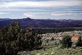
Squaw Ridge Lava Field
| Squaw Ridge Lava Field | |
|---|---|
 The Squaw Ridge lava field, also known as the East lava field, is the middle of a group of three young basaltic fields located in the High Lava Plains SE of Newberry volcano. | |
| Highest point | |
| Elevation | 1,711 m (5,614 ft) [1] |
| Coordinates | 43°28′20″N 120°45′13″W / 43.47222°N 120.75361°WCoordinates: 43°28′20″N 120°45′13″W / 43.47222°N 120.75361°W [1] |
| Geography | |
| Location |
Lake County, Oregon, United States |
| Geology | |
| Age of rock | Holocene?[1] |
| Mountain type | Volcanic field[1] |
The Squaw Ridge lava field, also known as the East lava field, is a young basaltic field located in the U.S. state of Oregon southeast of Newberry Volcano.[1]
Notable Vents
| Name | Elevation | Location | Last eruption |
| Lava Mountain[2] | 1,711 metres (5,614 ft) | 43°28′19″N 120°45′14″W / 43.472°N 120.754°W | - |
| Twin Buttes[2] | 1,525 metres (5,003 ft) | 43°28′N 120°44′W / 43.47°N 120.73°W | - |
See also
References
- 1 2 3 4 5 "Squaw Ridge Lava Field". Global Volcanism Program. Smithsonian Institution.. Retrieved 2008-05-13.
- 1 2 "Squaw Ridge Lava Field - Synonyms and Subfeatures". Global Volcanism Program. Smithsonian Institution. Retrieved 2008-05-13.
This article is issued from Wikipedia - version of the 9/22/2016. The text is available under the Creative Commons Attribution/Share Alike but additional terms may apply for the media files.