Spioenkop Dam
| Spioenkop Dam | |
|---|---|
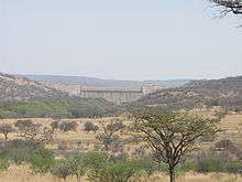 Spioenkop Dam seen from the R600 road | |
 Location of Spioenkop Dam in South Africa | |
| Official name | Spioenkop Dam |
| Country | South Africa |
| Location | KwaZulu-Natal |
| Coordinates | 28°40′52″S 29°31′01″E / 28.681°S 29.517°ECoordinates: 28°40′52″S 29°31′01″E / 28.681°S 29.517°E |
| Purpose | Irrigation |
| Opening date | 1972 |
| Owner(s) | Department of Water Affairs |
| Dam and spillways | |
| Type of dam | Earth fill dam |
| Impounds | Tugela River |
| Height | 53 m |
| Reservoir | |
| Creates | Spioenkop Dam Reservoir |
| Total capacity | 272,265 megalitres (272.265 hm3) |
| Catchment area | 2,452 square kilometres (947 sq mi) |
| Surface area | 15.314 km2 |
Spioenkop Dam impounds the Tugela River in KwaZulu-Natal. It is located within a nature reserve by the same name. The dam was commissioned in 1972, has a capacity of 272,265 cubic metres (9,614,900 cu ft), and a surface area of 15.314 square kilometres (5.913 sq mi), the dam wall is 53 metres (174 ft) high. Spion Kop (hill) is located 2.5 km to the north of the dam.
See also
References
External links
This article is issued from Wikipedia - version of the 9/26/2015. The text is available under the Creative Commons Attribution/Share Alike but additional terms may apply for the media files.