South Dakota Highway 42
| ||||
|---|---|---|---|---|
|
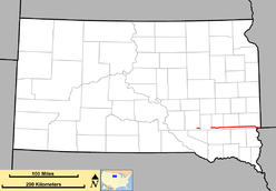
Route of SD 42 (in red) | ||||
| Route information | ||||
| Defined by SDCL §31-4-162 | ||||
| Maintained by SDDOT | ||||
| Length: | 71.973 mi[1] (115.829 km) | |||
| Western segment | ||||
| Length: | 5.870 mi (9.447 km) | |||
| West end: |
| |||
| East end: | Aurora–Davison county line | |||
| Central segment | ||||
| Length: | 59.231 mi (95.323 km) | |||
| West end: |
| |||
| Major junctions: |
| |||
| East end: | Sioux Falls | |||
| Eastern segment | ||||
| Length: | 6.872 mi (11.059 km) | |||
| West end: |
| |||
| East end: |
| |||
| Location | ||||
| Counties: | Aurora, Davison, Hanson, McCook, Minnehaha | |||
| Highway system | ||||
| ||||
South Dakota Highway 42 (SD 42) is a segmented state highway in southeastern South Dakota. The first segment is a six-mile-long (9.7 km) highway in Aurora County. The second and longest is 60 miles (97 km) long and connects Ethan and Sioux Falls. The final segment connects Sioux Falls to Iowa Highway 9 southeast of Rowena.
Route description
The westernmost segment of SD 42 begins at a junction with U.S. Route 281 (US 281) and travels east through open farmland. This is the shortest of the three segments; it is only about six miles (9.7 km) long, and it ends as the roadway crosses from Aurora County into Davison County.[2]
The central segment of the highway begins at an intersection with SD 37 in rural Davison County. It heads east and crosses the BNSF Railway.[3] Just east of the railroad, the route passes through the town of Ethan, then enters Hanson County. About six miles (9.7 km) farther east, SD 42 bends slightly to the south and crosses the James River. The highway continues east through the flat prairie and enters McCook County.
About five miles (8.0 km) east of the county line, the highway enters the city of Bridgewater. Here, it curves to the northeast and crosses another branch of the BNSF Railway[3] before meeting the eastern terminus of SD 262. SD 42 then curves back to the east and leaves Bridgewater. It continues through flat farmland, intersecting US 81 and passing over the west fork of the Vermillion River. The route heads east about ten miles (16 km) before crossing the east fork of the Vermillion River, and then entering Minnehaha County.

In Minnehaha County, SD 42 intersects SD 19, and the two highways run east for about one mile (1.6 km) before SD 19 splits off to the north, and SD 42 continues east toward Sioux Falls. It intersects the northern terminus of SD 17 approximately three miles (4.8 km) east of the city. The central segment of SD 42 ends at Tea-Ellis Road near the Sioux Falls city limits.[4]
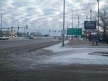
The easternmost segment of SD 42 begins at Six Mile Road east of the city of Sioux Falls. It runs southeast, concurrent with SD 11 along Arrowhead Parkway. The two highways pass by a golf course and a park before crossing the Big Sioux River. East of the river, SD 11 turns to the north toward Brandon, and SD 42 curves to the east. The highway passes through the unincorporated community of Rowena before curving due south and crossing the Iowa state line. The route continues into Iowa as Iowa Highway 9.[5]
Major intersections
| County | Location | mi[1] | km | Destinations | Notes | ||
|---|---|---|---|---|---|---|---|
| Aurora | | 0.000 | 0.000 | ||||
| Aurora–Davison county line | | 5.870 | 9.447 | End state maintenance | |||
| Gap in route | |||||||
| Davison | Ethan | 5.870 | 9.447 | ||||
| Hanson | | 25.049 | 40.312 | ||||
| McCook | Bridgewater | 31.811 | 51.195 | ||||
| | 37.100 | 59.707 | |||||
| Minnehaha | | 51.089 | 82.220 | West end of SD 19 concurrency | |||
| Pumpkin Center | 52.102 | 83.850 | East end of SD 19 concurrency | ||||
| | 62.101 | 99.942 | |||||
| Sioux Falls | 65.101 | 104.770 | Tea-Ellis Road | Gap in state maintenance | |||
| Gap in route | |||||||
| Minnehaha | Sioux Falls | 65.101 | 104.770 | Six Mile Road | Resume state maintenance, west end of SD 11 concurrency | ||
| | 67.334 | 108.364 | East end of SD 11 concurrency | ||||
| | 71.973 | 115.829 | Continuation into Iowa | ||||
1.000 mi = 1.609 km; 1.000 km = 0.621 mi
| |||||||
References
- 1 2 "State Highway Log" (PDF). Mitchell region: South Dakota Department of Transportation. January 2011. pp. 100–104. Retrieved December 21, 2011.
- ↑ Google (December 20, 2013). "Western segment of SD 42" (Map). Google Maps. Google. Retrieved December 20, 2013.
- 1 2 "Official South Dakota Rail Map" (PDF). South Dakota Department of Transportation. October 2009. Retrieved December 20, 2013.
- ↑ Google (December 20, 2013). "Central segment of SD 42" (Map). Google Maps. Google. Retrieved December 20, 2013.
- ↑ Google (December 20, 2013). "Eastern segment of SD 42" (Map). Google Maps. Google. Retrieved December 20, 2013.

