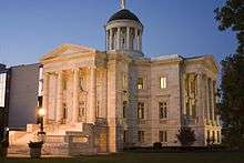
Somerset County Courthouse (New Jersey)

The Somerset County Courthouse is located in Somerville, New Jersey, United States.
The courthouse, built between 1907 and 1909 in the Palladian style and is faced with Sylacauga marble. The courthouse underwent a $US 6 million renovation between 1989 and 1996. Attached to the courthouse is the First Reformed Church which was built in 1898. It has served as the county's Jury Assembly Room since it was renovated around 1985.
History
When Somerset County was chartered in 1688 most, if not all, judicial affairs were subject to the jurisdiction of the Middlesex County. This all changed in 1714 because the growing community was in need of its own court. The Colonial Assembly passed an act allowing for the building of a court house in Somerset County. County Freeholders chose Six Mile Run (in Franklin Township), as the site to build the new courthouse and jail. In 1737, the jail and courthouse caught fire and burned to the ground. Everything was destroyed. The Freeholders then decided, due to the fire and due to the inaccessibility of the courthouse, to move its location to present-day Millstone. This courthouse served the county until about 1779. This is when invading British forces burned down the courthouse and again most of the records were lost. A committee was appointed by the county in 1782 to build a new courthouse. The Committee met with members of the Dutch Reformed Church (the Consistory of the Church of Raritan) and voted to join together and build a courthouse. This association between the court and the church lasted until 1788 when the Dutch Reformed Church relinquished its previous agreements for use of the courthouse, located in Somerville.
On 24 September 2010 at 10:23 a.m. a bomb threat was called in evacuating the court house and nearby buildings.[1]
Notable cases
- Hall-Mills Murder (1926)
References
- ↑ Rick Epstein (24 September 2010). "Bomb scare empties Somerset County Courthouse in Somerville". nj.com. New Jersey On-Line LLC. Retrieved 3 October 2010.
External links
- Map: 40°34′07″N 74°36′38″W / 40.56861°N 74.61056°WCoordinates: 40°34′07″N 74°36′38″W / 40.56861°N 74.61056°W