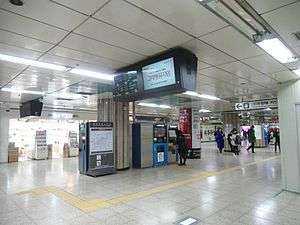
Sillim Station
Sillim Station | |
|---|---|
 | |
| Korean name | |
| Hangul | 신림역 |
| Hanja | 新林驛 |
| Revised Romanization | Sillim-yeok |
| McCune–Reischauer | Sillim-yǒk |
| General information | |
| Location |
1467-10 Sillim-dong, 1614 Nambusunhwanno Jiha, Gwanak-gu, Seoul[1] |
| Operated by | Seoul Metro |
| Line(s) | Line 2 |
| Platforms | 1 |
| Tracks | 2 |
| Construction | |
| Structure type | Underground |
| Key dates | |
| May 22, 1984[1] | Line 2 opened |
| Traffic | |
| Passengers |
(Daily) Based on Jan-Dec of 2012. Line 2: 145,527[2] |
Sillim Station is a station on the Seoul Subway Line 2. It is located in Sillim-dong, Gwanak-gu, Seoul.[3]
Station layout
| G | Street level | Exit |
| L1 Concourse |
Lobby | Customer Service, Shops, Vending machines, ATMs |
| L2 Platform level |
Inner loop | ← Line 2 toward Chungjeongno (Sindaebang) |
| Outer loop | → Line 2 toward City Hall (Bongcheon) → | |
Vicinity
The Sillim area is a crowded area because of many shopping malls and restaurants. Sundae chon is famous among residents. Renaissance shopping mall is located nearby, which sells articles from men's clothes to accessories. Restaurants like Lotteria, Hans Deli, as well as Krispy Kreme are also popular and close to the station. Seoul National University and Soongsil University are not far from here.
Passenger load
In a survey conducted in 2011 by the Ministry of Land, Transport and Maritime Affairs on 92 Administrative divisions across the country, it reported that Sillim Station is the fifth busiest public transit stop following Gangnam Station, Jamsil Station, Sadang Station and Seolleung Station.[4]
References
- 1 2 "신림역" (in Korean). Doopedia. Retrieved 2016-06-23.
- ↑ Monthly Number of Passengers between Subway Stations. Korea Transportation Database, 2013. Retrieved 2013-10-15.
- ↑ "Sillim". Seoul Metro. Retrieved 2016-06-23.
- ↑ "Gangnam Busiest Subway Station in Korea". Chosun Ilbo. 23 April 2012. Retrieved 25 April 2012.
| Preceding station | Seoul Metropolitan Subway | Following station | ||
|---|---|---|---|---|
toward City Hall | Line 2 | toward Chungjeongno |
Coordinates: 37°29′03″N 126°55′47″E / 37.48417°N 126.92972°E