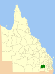
Shire of Tara
| Shire of Tara Queensland | |||||||||||||
|---|---|---|---|---|---|---|---|---|---|---|---|---|---|
 Location within Queensland | |||||||||||||
| Population | 3,676 (2006 census)[1] | ||||||||||||
| • Density | 0.31466/km2 (0.81498/sq mi) | ||||||||||||
| Established | 1912 | ||||||||||||
| Abolished | 2008 | ||||||||||||
| Area | 11,682.3 km2 (4,510.6 sq mi) | ||||||||||||
| Council seat | Tara | ||||||||||||
| Region | Darling Downs | ||||||||||||
 | |||||||||||||
| Website | Shire of Tara | ||||||||||||
| |||||||||||||
The Shire of Tara was a local government area in the Darling Downs region of Queensland, Australia. The shire, administered from the town of Tara, covered an area of 11,682.3 square kilometres (4,510.6 sq mi), and existed as a local government entity from 1912 until 2008, when it amalgamated with the Town of Dalby and the Shires of Chinchilla, Murilla and Wambo and the southern part of Taroom to form the Western Downs Region.
Important industries in the area include wheat, beef and wool. In recent years there have been large scale rural subdivisions developed in the area. Prickly Pear infestation in the early 1900s had a devastating effect on the area that was only alleviated by the introduction of the cactoblastis moth.
Attractions in Tara include Southwood National Park, a remnant area of the southern brigalow belt.
History
The Shire of Tara was established on 12 January 1912 by severance from the Shire of Wambo.
On 15 March 2008, under the Local Government (Reform Implementation) Act 2007 passed by the Parliament of Queensland on 10 August 2007, the Shire of Tara merged with the Town of Dalby and the Shires of Chinchilla, Murilla and Wambo and the southern part of Taroom to form the Western Downs Region.
Towns and localities
The Shire of Tara included the following settlements:
|
Towns: |
Localities:
|
Chairmen
- 1927: Andrew Watt Adams [2]
Population
| Year | Population |
|---|---|
| 1921 | 1,313 |
| 1933 | 1,785 |
| 1947 | 2,278 |
| 1954 | 3,149 |
| 1961 | 3,558 |
| 1966 | 3,525 |
| 1971 | 3,337 |
| 1976 | 3,098 |
| 1981 | 3,116 |
| 1986 | 3,656 |
| 1991 | 3,624 |
| 1996 | 3,501 |
| 2001 | 3,806 |
| 2006 | 3,584 |
References
- ↑ Australian Bureau of Statistics (25 October 2007). "Tara (S) (Local Government Area)". 2006 Census QuickStats. Retrieved 15 June 2011.
- ↑ Pugh, Theophilus Parsons (1927). Pugh's Almanac for 1927. Retrieved 13 June 2014.
Coordinates: 27°16′34″S 150°27′24.2″E / 27.27611°S 150.456722°E