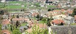
Settimo Vittone
| Settimo Vittone | ||
|---|---|---|
| Comune | ||
| Comune di Settimo Vittone | ||
|
Panorama | ||
| ||
 Settimo Vittone Location of Settimo Vittone in Italy | ||
| Coordinates: 45°33′N 7°50′E / 45.550°N 7.833°E | ||
| Country | Italy | |
| Region | Piedmont | |
| Province / Metropolitan city | Turin (TO) | |
| Frazioni | Cesnola, Montestrutto, Torredaniele | |
| Government | ||
| • Mayor | Sabrina Noro | |
| Area | ||
| • Total | 23.2 km2 (9.0 sq mi) | |
| Elevation | 280 m (920 ft) | |
| Population (31 December 2010[1]) | ||
| • Total | 1,576 | |
| • Density | 68/km2 (180/sq mi) | |
| Demonym(s) | Settimesi | |
| Time zone | CET (UTC+1) | |
| • Summer (DST) | CEST (UTC+2) | |
| Postal code | 10010 | |
| Dialing code | 0125 | |
| Patron saint | St. Andrew | |
| Saint day | 30 Novembre | |
Settimo Vittone is a comune (municipality) in the Metropolitan City of Turin, Piedmont, northern Italy. It is located about 50 kilometres (31 mi) north of Turin, in the Canavese traditional region.
Main sights
The pieve of St. Lawrence.
Madonna and Child fresco (detail) in the apse of St. Lawrence pleban church.
The main sights are the pieve (pleban church) and the baptistery of St. Lawrenece, most likely dating to the late 9th century. It is one of the main examples of pre-Romanesque architecture in Piedmont. Instead in Romanesque are the bell tower and the rectangular apse. It is home to numerous frescoes, dating from the mid-11th to the late 15th centuries.
The Colma di Mombarone mountain is located nearby.
References
| Wikimedia Commons has media related to Settimo Vittone. |
This article is issued from Wikipedia - version of the 10/8/2016. The text is available under the Creative Commons Attribution/Share Alike but additional terms may apply for the media files.

