Seliamedu
| Seliamedu | |
|---|---|
| Village | |
 Seliamedu  Seliamedu Location in Puducherry, India | |
| Coordinates: 11°49′30″N 79°45′12″E / 11.82493°N 79.753232°ECoordinates: 11°49′30″N 79°45′12″E / 11.82493°N 79.753232°E | |
| Country |
|
| State | Puducherry |
| District | Pondicherry |
| Taluk | Bahour |
| Commune | Bahour |
| Population (2001) | |
| • Total | 36,983 |
| Languages | |
| • Official | French, Tamil, English |
| Time zone | IST (UTC+5:30) |
| PIN | 607 402 |
| Telephone code | 0413 |
| Vehicle registration | PY-01 |
| Sex ratio | 50% ♂/♀ |
Seliamedu (Tamil: சேலியமேடு) is a village,[1] sub-taluk in Bahour Commune of Bahour taluk in the Union Territory of Puducherry, India. It lies on north side in the Bahour Enclave of Puducherry district.
Geography
Seliamedu is bordered by Bahour in the west, Keezh Kumaramangalam village of Tamil nadu in the north, Nagappanur village of Tamil nadu in east and Kudiyiruppupalayam in the south.
Road Network
Seliamedu lies on Villianur - Bahour road (RC-18). Seliamedu is also connected by TN Palayam-Bahour road.
Villages
Following are the list of villages under Seliamedu Village Panchayat.
- Seliamedu
- Aranganur
Gallery
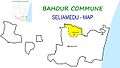 Map of Seliamedu Village Panchayat
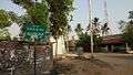 Seliamedu, Bahour Commune
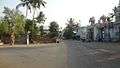 Siva Temple, Seliamedu, Bahour Commune
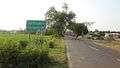 Aranganur, Seliamedu, Bahour Commune
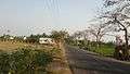 RC-18 Road at Aranganur, Seliamedu, Bahour Commune
Politics
Seliamedu is a part of Embalam (Union Territory Assembly constituency) which comes under Puducherry (Lok Sabha constituency)
References
External links
This article is issued from Wikipedia - version of the 8/27/2016. The text is available under the Creative Commons Attribution/Share Alike but additional terms may apply for the media files.