Ring's End Local Nature Reserve
| Ring's End | |
|---|---|
 | |
| Type | Local Nature Reserve |
| Location | March, Cambridgeshire |
| OS grid | TF 402 017 |
| Area | 8.5 hectares |
| Managed by | Cambridgeshire County Council |
Ring's End is an 8.5 hectare Local Nature Reserve which runs south from the hamlet of Ring's End towards March in Cambridgeshire. It is owned and managed by Cambridgeshire County Council.[1][2]
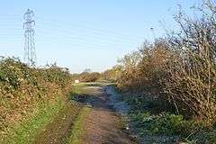
This is a linear site along a disused railway embankment, with views over the Fens. There are also three ponds, reedbeds and areas of scrub.[1] The soil is poor in nutrients, which has allowed uncommon flowering plants such as coltsfoot to become established. Trees include ash and white willow.[3]
The site can be accessed from Twenty Foot Road, and National Cycle Route 63 runs through it.[1]
| Wikimedia Commons has media related to Ring's End. |
References
- 1 2 3 "Ring's End". Local Nature Reserves. Natural England. 21 February 2013. Retrieved 20 November 2016.
- ↑ "Map of Ring's End". Local Nature Reserves. Natural England. Retrieved 20 November 2016.
- ↑ "Local nature reserves : Ring's End". Cambridgeshire County Council. Retrieved 20 November 2016.
Coordinates: 52°35′42″N 0°04′08″E / 52.595°N 0.069°E
This article is issued from Wikipedia - version of the 11/20/2016. The text is available under the Creative Commons Attribution/Share Alike but additional terms may apply for the media files.