Ridgefield Rail Trail
| Ridgefield Rail Trail | |
|---|---|
| Location | Ridgefield, CT to Branchville, CT |
| Length | 2.3 mi (3.7 km) |
| Trailheads | Ridgefield Branchville |
| Use | Walking, Running, Cross Country Skiing |
| Difficulty | Easy |
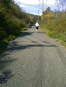
| Surface | Cinder (with asphalt at all trailheads and street crossings) |
| Hours | Dawn to dusk, year-around |
| Amenities | Benches, Mile markers |
| Bathrooms | None |
The Ridgefield Rail Trail (RRT) is a rail trail in Ridgefield, Connecticut. It follows an old rail corridor for 2.3 miles (3.7 km) from downtown Ridgefield to the Branchville section of town.
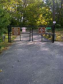
The trail can be used for walking, jogging, and cross-country skiing, and it is open from dawn to dusk, seven days a week throughout the year. The trail is lined with many trees native to New England. The trail's motto, which is displayed at the Ridgefield Trailhead is, "Take only photographs, leave only footprints, keep only memories".
Historical development
Historical significance
Branchville was named for the "branch" rail line from the Danbury and Norwalk Railroad to Ridgefield. The line was built in 1870. Passenger service on the branch line was available into town until 1925 and freight service lasted until 1964. While the area had been mostly farmland with a mill or two, the announcement of the railroad encouraged development. It included more mills, stores, a hotel, a machinery factory, a noted mineral quarry, a post office, and a school, which still stands.
Trail's history and evolution
The Ridgefield Rail Trail was built by Connecticut Light and Power (CL&P) and opened December 11, 2000.[1] CL&P is the owner of this abandoned rail corridor and built the rail trail at no cost to the town of Ridgefield. The project was spearheaded by First Selectman Rudy Marconi as an enhancement to open space and as the town's first ever off-road trail.
Trail development
Design and construction
The trail was designed by Bill O'Neill from the engineering firm Fuss & O'Neill. The majority of the trail is made of crushed cinder. The trail is asphalt at the entrance, exit and at all street crossings. The trail width varies throughout, ranging between six and ten feet (1.8 and 3.0 m).
Trail amenities
Parking is available at the Ridgefield trailhead on Halpin Lane and at the Ridgefield Playhouse. There are benches located throughout the rail, as well as distance markers every 1⁄5 mile (320 m).
Community
Trail supporters
The Ridgefield Rail Trail is managed and maintained by CL&P. In certain situations, local Ridgefield residents have volunteered in coordination with CL&P. This has particularly occurred in an effort to paint over graffiti which have appeared on electrical poles.[2]
Special events
Each year the RRT hosts numerous hikes which are organized by the The Ridgefield Discover Center. In recent years these have included the "Fall for Ridgefield Weekend Hike" and the "Hike off the Turkey".
References
- ↑ Ridgefield Walk Book. Ridgefield, CT: The Ridgefield Conservation Commission. 2006. p. 56. Check date values in:
|access-date=(help); - ↑ Marcia Kendall (14 December 2009). "Vandals Graffiti the Rail Trail". Patch Media. Retrieved 23 April 2012.