Ravela
| Ravela రావెల | |
|---|---|
| village | |
 Ravela  Ravela Location in Andhra Pradesh, India | |
| Coordinates: 16°25′30″N 80°20′52″E / 16.424889°N 80.347824°ECoordinates: 16°25′30″N 80°20′52″E / 16.424889°N 80.347824°E | |
| Country |
|
| State | Andhra Pradesh |
| District | Guntur |
| Government | |
| • Body | Panchayat |
| Area | |
| • Total | 12.0987 km2 (4.6713 sq mi) |
| Languages | |
| • Official | Telugu |
| Time zone | IST (UTC+5:30) |
| Nearest city | Guntur |
| Lok Sabha constituency | Guntur |
| Vidhan Sabha constituency | Tadikonda |
| Civic agency | Panchayat |
Ravela is a village in Tadikonda Mandal of Guntur district in the Indian state of Andhra Pradesh. It lies 18 kilometres (11 mi) from Guntur City.
Transport
The village has road links with nearby villages Pamulapadu, Ponnekallu, varagani,Bejethpuram, Bandarpalli, Mandhapadu and further to Guntur City. The nearest railway stations are Mandhpadu and "Siripuram". The latter is 3 km away on the main railway network line between Guntur City and Secunderabad.
Main occupation
Agriculture is the main occupation. The main crops are chili pepper, cotton, rice, and tobacco.
Schools
This village has a Government Elementary school (1 to 5th grade) and Zilla Praza Parishad School (ZPP) along with small private schools. ZPP is located across the only substantial water body in the village. ZPP was built in the 1950s. More than 10% of the students become professionals: doctors, engineers, Police superintendent, DSP, etc.
Places of worship
Ravela is known for communal harmony. This village has temples of Lord Krishna, Lord Rama and Hanuman. Venugoplaswamy Temple is believed to be about 600 years old. Other places of worship include three church's and two mosques.
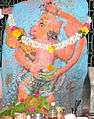 Hanuman Temple Ravela
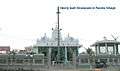 Newly Built Sivalayam in Ravela