Rathcunikeen
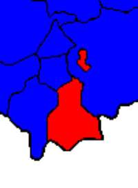
Position of Ballymurreen parish within the civil parishes of south-eastern North Tipperary, showing that Rathcunikeen is an exclave
| Rathcunikeen | |
|---|---|
| townland | |
 Rathcunikeen Location in Ireland | |
| Coordinates: 52°39′41″N 7°44′43″W / 52.6613772°N 7.7452851°WCoordinates: 52°39′41″N 7°44′43″W / 52.6613772°N 7.7452851°W | |
| Country | Ireland |
| Province | Munster |
| County | County Tipperary |
Rathcunikeen or Rathcumrikeen is a townland in the civil parish of Ballymurreen, County Tipperary in Ireland.[1] It is an exclave of the parish, as it is surrounded by the neighbouring civil parish of Borrisleigh.
References
This article is issued from Wikipedia - version of the 1/11/2015. The text is available under the Creative Commons Attribution/Share Alike but additional terms may apply for the media files.