Rahmat Khali Canal
| Rahmat Khali Canal (রহমত খালি খাল) | |
| Lakshmipur Khal, Rahmat Khali Khal | |
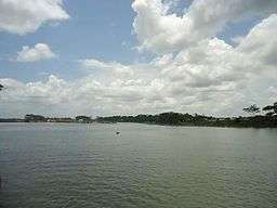 Photographed at Moju Chowdhury Hat mouth of Meghna River | |
| Countries | |
|---|---|
| Region | Chittagong Division |
| Districts | Lakshmipur District, Noakhali District, Feni District, Begumganj |
| City | Lakshmipur, Moju Chowdhury Hat |
| Landmark | Lakshmipur Sadar Upazila |
| Source | Meghna River |
| - location | Meghna, Lakshmipur District, Chittagong Division, Chittagong, Bangladesh |
| - elevation | 75 m (246 ft) |
| - length | 7,350 m (24,114 ft) |
| Mouth | Bay of Bengal |
| Length | 137 km (85 mi) |
Rahmat Khali Canal (Bengali: রহমত খালি খাল) or Lakshmipur Khal Stream is a canal in that flows through Chittagong Division , in Bangladesh . in Begumganj Upazila.[1] it is known simply as WAPDA canal.in the Bangladesh Half Governmental Organization.[2]
Description
The estimated terrain elevation above sea level is 2 metres. Well known places, streets and travel smallest river in the Bangladesh in the Division of Chittagong in the District of Lakshmipur District this river is around the Three Districts of Bangladesh, it's starts at Feni middle of Noakhali ended at Lakshmipur Mouth of the Meghna River Meghna is the main stream River than the Bay of Bengal, the river is small but it has an area of 85 km². square metres from venue of those cities. This river is an important river in the Lakshmipur Moju Chowdhury Hat Noakhali Feni, Begumganj another city's of those Districts. Bangladesh Water Development Board.
Geography
This canal is located at 22°51′57″N 90°45′38″E / 22.8658645°N 90.7605756°E Lakshmipur District includes others Towns in the City of Lakshmipur municipality and last Moju Chowdhury Hat. this canal it has an areas of total 85 km². kilometres length of 141 km².
Gallery
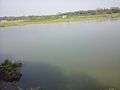 WAPDA Canal in the Moju Chowdhury Hat Lakshmipur
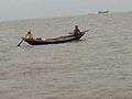 fishermen they are going to catch fish in the River
See also
References
- ↑ Sultan Mahmud Bhuiyan (2012), "Begumganj Upazila", in Sirajul Islam and Ahmed A. Jamal, Banglapedia: National Encyclopedia of Bangladesh (Second ed.), Asiatic Society of Bangladesh
- ↑ Salinity Data Available -Bangladesh Water Development Board
External links
- Water Development Board Ministry
- Salinity Data Available-Bangladesh Water Development Board.
- Water Simpling Points levels.
- processing flood forecasting
Coordinates: 22°51′57″N 90°45′38″E / 22.8658645°N 90.7605756°E