Qullqi Chaka Punta
| Qullqi Chaka Punta | |
|---|---|
 Qullqi Chaka Punta Location within Bolivia | |
| Highest point | |
| Elevation | 4,380 m (14,370 ft) [1] |
| Coordinates | 19°50′45″S 65°59′23″W / 19.84583°S 65.98972°WCoordinates: 19°50′45″S 65°59′23″W / 19.84583°S 65.98972°W |
| Geography | |
| Location |
Bolivia, Potosí Department |
| Parent range | Andes |
Qullqi Chaka Punta (Aymara and Quechua qullqi silver, chaka bridge, Quechua punta peak, ridge,[2][3][4] "silver bridge peak (or ridge)", also spelled Colquechaca Punta) is a mountain in the Bolivian Andes which reaches a height of approximately 4,380 m (14,370 ft). It is located in the Potosí Department, Antonio Quijarro Province, Porco Municipality. It lies northwest of K'uyka and west of Phujuni.[1][5]
References
- 1 2 Bolivian IGM map 1:50,000 Estancia Kollpa 6434-III
- ↑ Radio San Gabriel, "Instituto Radiofonico de Promoción Aymara" (IRPA) 1993, Republicado por Instituto de las Lenguas y Literaturas Andinas-Amazónicas (ILLLA-A) 2011, Transcripción del Vocabulario de la Lengua Aymara, P. Ludovico Bertonio 1612 (Spanish-Aymara-Aymara-Spanish dictionary)
- ↑ Teofilo Laime Ajacopa, Diccionario Bilingüe Iskay simipi yuyayk'ancha, La Paz, 2007 (Quechua-Spanish dictionary)
- ↑ David Weber, A Grammar of Huallaga (Huánuco) Quechua, University of California Press, p. 185
- ↑ "Porco". INE, Bolivia. Retrieved April 29, 2016.
Capital: Potosí | ||
| Provinces | 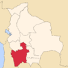 | |
| Municipalities (and seats) |
| |
This article is issued from Wikipedia - version of the 4/29/2016. The text is available under the Creative Commons Attribution/Share Alike but additional terms may apply for the media files.