Qallwa (Andagua)
For the mountain on the border of the districts of Ayo, Chachas and Choco in the Castilla Province, Arequipa Region, Peru, see Qallwa.
| Qallwa | |
|---|---|
 | |
| Highest point | |
| Elevation | 5,110 m (16,770 ft) [1] |
| Coordinates | 15°30′49″S 72°26′38″W / 15.51361°S 72.44389°WCoordinates: 15°30′49″S 72°26′38″W / 15.51361°S 72.44389°W [1] |
| Geography | |
 Qallwa Peru | |
| Location | Peru, Arequipa Region |
| Parent range | Andes |
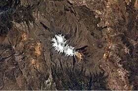
Qallwa (Quechua for a little branch, also for an instrument out of wood or bones which the weavers use to press the threads of the cloth,[2] hispanicized spelling Jallhua) is a 5,110 m (16,765 ft) high mountain in the Andes of Peru. It is located in the Arequipa Region, Castilla Province, Andagua District.[3]
References
- 1 2 "Cerro Jallhua". IGN, Peru. Retrieved August 8, 2015.
- ↑ Teofilo Laime Ajacopa, Diccionario Bilingüe Iskay simipi yuyayk'ancha, La Paz, 2007 (Quechua-Spanish dictionary)
- ↑ escale.minedu.gob.pe - UGEL map of the Caylloma Province 1 (Arequipa Region)
This article is issued from Wikipedia - version of the 3/7/2016. The text is available under the Creative Commons Attribution/Share Alike but additional terms may apply for the media files.