Provincial Highway 19 (Taiwan)
| ||||
|---|---|---|---|---|
| 台19線 | ||||
| Central Highway | ||||
 | ||||
| Route information | ||||
| Maintained by Directorate General of Highways | ||||
| Length: | 140.3 km (87.2 mi) | |||
| Major junctions | ||||
| North end: |
| |||
|
| ||||
| South end: |
| |||
| Highway system | ||||
| ||||

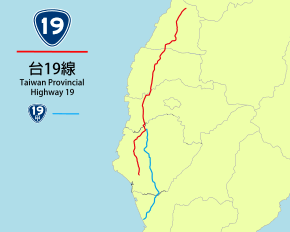
Provincial Highway 19 (Chinese: 台19線) is a North-South highway from Changhua City in Changhua County to Yongkang in Tainan City. The highway is known as Central Highway (中央公路). The highway lies between the coastal PH 17 and the inland PH 1 which serves many of the major cities in central and southern Taiwan. The total length of the highway is 140.3 km.[1]
Route Description
The highway begins at the intersection with PH 1 in downtown Changhua City. After the intersection with Freeway 1, the highway continues south and meets PH 76 in Puyan, Changhua County, PH 78 in Yuanchang, Yunlin County, PH 82 in Puzi, Chiayi County, as well as PH 84 in Xuejia, Tainan City. The highway meets with Freeway 8 in Anding, before ending at the urban district of Yongkang, Tainan City, at the intersection with PH 1.
The highway passes through the following counties and cities: Changhua County, Yunlin County, Chiayi County, and Tainan City.
Spur Routes
-
 PH 19a: The highway connects the parent route in Yanshui, Tainan City, with PH 17 in Zihguan, Kaohsiung County. The highway is also the longest spur routes in the provincial highway system. The total length is 78.4 km.
See also
References
External links
| Wikimedia Commons has media related to Provincial Highway 19 (Taiwan). |
Provincial Highways of Taiwan | ||
|---|---|---|