Promontorium Laplace

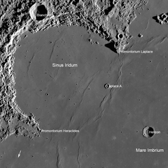
Annotated Sinus Iridum by LRO; Promontorium Laplace is labeled at upper-right.
Promontorium Laplace is a raised mountainous cape situated at the end of Montes Jura in Mare Imbrium on the near side of the Moon. Its selenographic coordinates are 46.0° N, 26.0° W and it is 2600 meters high. It forms the northeast boundary of the bay of Sinus Iridum.
It is named after Pierre Simon marquis de Laplace, an 18th-century French astronomer, mathematician, and physicist.
External Links
- Wood, Chuck (2006-08-20). "Out the Porthole". Lunar Photo of the Day. Retrieved 2016-09-18., excellent earth-based image of Sinus Iridum and vicinity, including Promontorium Laplace
This article is issued from Wikipedia - version of the 9/19/2016. The text is available under the Creative Commons Attribution/Share Alike but additional terms may apply for the media files.