Perali
| Perali పేరలి | |
|---|---|
| town | |
 Perali  Perali Location in Andhra Pradesh, India | |
| Coordinates: 15°53′10″N 80°32′49″E / 15.886°N 80.547°ECoordinates: 15°53′10″N 80°32′49″E / 15.886°N 80.547°E | |
| Country |
|
| State | Andhra Pradesh |
| District | Guntur |
| Population | |
| • Total | 10,443 |
| Languages | |
| • Official | Telugu,urdu |
| Time zone | IST (UTC+5:30) |
| PIN | 522 111[1] |
Perali is a small village located 7.9 km away from Bapatla, Andhra Pradesh, India. Perali is part of the Karlapalem mandal in Guntur district. Perali is located 5.6 km from its mandal main town Karlapalem, 46.5 km distance from the district's main city Guntur and 274 km distance from the state capital Hyderabad.The village has an estimated population of 10403 with 5295 Male and 5108 Female. It is famous for the historic temple called the 'Bala tripura sundari sametha someswara swamy devasthanam' The temple is constructed in 1900 and the idols are found in excavation at the village.
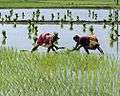
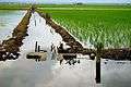
Farming and Vegetation
Perali is located very near to the Bay of Bengal and Machilipatnm port. Suryalanka is a tourist shore point very near to Perali. It is surrounded by forest on one side and the green farms on the rest. Farmers occupy major part of the population and the major crop being paddy. Famous variety of paddy bpt ( bapatla ) is grown extensively here. Lands here are fertile and are irrigated under river krishna.
References
- ↑ "Details of Post Office Perali, Guntur". pincode.net. Retrieved 3 September 2011.