Opoczno County
| Opoczno County Powiat opoczyński | |||
|---|---|---|---|
| County | |||
| |||
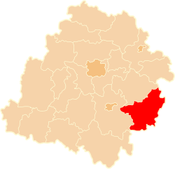
 Location within the voivodeship | |||
| Coordinates (Opoczno): 51°23′N 20°17′E / 51.383°N 20.283°ECoordinates: 51°23′N 20°17′E / 51.383°N 20.283°E | |||
| Country |
| ||
| Voivodeship | Łódź | ||
| Seat | Opoczno | ||
| Gminas | |||
| Area | |||
| • Total | 1,038.77 km2 (401.07 sq mi) | ||
| Population (2006) | |||
| • Total | 78,659 | ||
| • Density | 76/km2 (200/sq mi) | ||
| • Urban | 26,653 | ||
| • Rural | 52,006 | ||
| Car plates | EOP | ||
| Website | http://www.opocznopowiat.pl/ | ||
Opoczno County (Polish: powiat opoczyński) is a unit of territorial administration and local government (powiat) in Łódź Voivodeship, south-east Poland. It came into being on January 1, 1999, as a result of the Polish local government reforms passed in 1998. Its administrative seat and largest town is Opoczno, which lies 72 kilometres (45 mi) south-east of the regional capital Łódź. The only other town in the county is Drzewica, lying 15 km (9 mi) north-east of Opoczno.
The county covers an area of 1,038.77 square kilometres (401.1 sq mi). As of 2006 its total population is 78,659, out of which the population of Opoczno is 22,708, that of Drzewica is 3,945, and the rural population is 52,006.
Neighbouring counties
Opoczno County is bordered by Przysucha County to the east, Końskie County to the south, Piotrków County to the west and Tomaszów Mazowiecki County to the north-west.
Administrative division
The county is subdivided into eight gminas (two urban-rural and six rural). These are listed in the following table, in descending order of population.
| Gmina | Type | Area (km²) |
Population (2006) |
Seat |
| Gmina Opoczno | urban-rural | 190.5 | 35,418 | Opoczno |
| Gmina Drzewica | urban-rural | 118.4 | 11,053 | Drzewica |
| Gmina Sławno | rural | 128.5 | 7,421 | Sławno |
| Gmina Żarnów | rural | 140.7 | 6,260 | Żarnów |
| Gmina Białaczów | rural | 114.5 | 5,980 | Białaczów |
| Gmina Mniszków | rural | 123.8 | 4,788 | Mniszków |
| Gmina Paradyż | rural | 81.6 | 4,421 | Paradyż |
| Gmina Poświętne | rural | 140.9 | 3,318 | Poświętne |
Opoczno County in the Past
The history of Opoczno County dates back to the Middle Ages, when its present territory was divided between the castellanies of Skrzynno and Zarnow. By early 14th century, Opoczno emerged as the most important urban center of the region, and when castellanies were replaced by counties, the Opoczno County ruled by a starosta was created some time between 1346 – 1368.
Until the Partitions of Poland, Opoczno County belonged to Lesser Polands’ Sandomierz Voivodeship. In the 16th century, the county had the area of 2454 sq. kilometers, with such towns, as Opoczno, Gowarczow, Bialaczow, Odrzywol, Drzewica and Gielniow.
In 1795 Opoczno County was annexed by the Habsburg Empire, and in 1807, it was part of Radom Department of the Duchy of Warsaw. In 1837, the county became part of Radom Governorate of Russian-controlled Congress Poland, and in 1867, Konskie County was carved out of southeastern part of Opoczno County.
In the Second Polish Republic, Opoczno County was part of Kielce Voivodeship (1919–39). On April 1, 1939, the county was moved to Lodz Voivodeship. During World War Two, Opoczno County was disbanded and merged into District (Kreis) of Tomaszow Mazowiecki. After the war, in 1944 - 1950, Opoczno County belonged to Lodz Voivodeship. On July 1, 1950, it was moved to Kielce Voivodeship.


