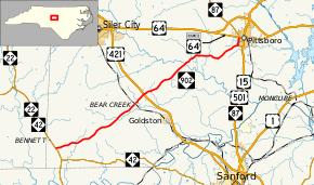
North Carolina Highway 902
| ||||
|---|---|---|---|---|
 | ||||
| Route information | ||||
| Maintained by NCDOT | ||||
| Length: | 24.9 mi[1] (40.1 km) | |||
| Existed: | 1929 – present | |||
| Major junctions | ||||
| West end: |
| |||
|
| ||||
| East end: |
| |||
| Location | ||||
| Counties: | Chatham | |||
| Highway system | ||||
| ||||
North Carolina Highway 902 (NC 902) is a primary state highway in the U.S. state of North Carolina. The highway connects southwest Chatham County with the county seat of Pittsboro. NC 902 has mostly rural routing going northeast most of the way. NC 902 was created in 1929 running from U.S. Route 64 (US 64) near Asheboro to Carthage but has since been truncated to its current routing over a long period of time.
Route description
NC 902 begins at NC 22/NC 42 south of Bennett. NC 902 heads east from there and crosses Falls Creek. From there NC 902 turns northeast and goes through Harpers Crossroads at the intersection of Siler City Glendon Road. The road intersects Edwards Hill Church Road (Secondary Road 1141 or SR 1141) on its way to Bear Creek. The road crosses over Bear Creek before reaching the eponymous town about one mile (1.6 km) down the road. When the route finally enters Bear Creek it crosses over a Norfolk Southern railroad and then intersects Old US 421 S.[2] After the road leaves Bear Creek it crosses over Sandy Branch. NC 902 intersects US 421 northeast of Bear Creek and from there continues northeast to cross Landrum Creek. Approximately one mile from the crossing of Landrum Creek, NC 902 turns to the east to parallel US 64. The road turns left on Pittsboro Goldston Road, and starts to again head northeast towards Pittsboro. NC 902 intersects NC 87 just south of downtown Pittsboro and turns north. NC 902 ends at US 64 Business (US 64 Bus.) in downtown Pittsboro.[3][4]
History
NC 902 first appeared on the North Carolina state highway map running from US 64/NC 90 in Asheboro to NC 74 (now NC 24/NC 27) west of Carthage. By 1933, NC 902 was removed off its routing from Bennett to its western terminus near Carthage. Instead NC 902 was routed along a concurrency with NC 64 and then along new routing to US 421 near Bear Creek.[5]
Between 1958-63, NC 902 was truncated, just south of Bennett, at NC 22/NC 42; the old alignment became part of NC 42.[6][7] In 1964, NC 902 was extended east to its current eastern terminus at US 64 (now US 64 Bus.) and NC 87 in Pittsboro.[8][9] In 2000, NC 87 was rerouted onto 0.8 miles (1.3 km) of NC 902 in Pittsboro.[10][11]
Junction list
The entire route is in Chatham County.
| Location | mi[1] | km | Destinations | Notes | |
|---|---|---|---|---|---|
| Bennett | 0.0 | 0.0 | |||
| Bear Creek | 11.7 | 18.8 | |||
| Pittsboro | 24.1 | 38.8 | South end of NC 87 overlap | ||
| 24.9 | 40.1 | North end of NC 87 overlap | |||
1.000 mi = 1.609 km; 1.000 km = 0.621 mi
| |||||
References
- 1 2 Google (2012-01-21). "North Carolina Highway 902" (Map). Google Maps. Google. Retrieved 2012-01-21.
- ↑ North Carolina's Railroad System (Map). Cartography by Rail Division. North Carolina Department of Transportation. March 2013. Archived from the original on March 4, 2014. Retrieved March 2014. Check date values in:
|access-date=(help) - ↑ Google (March 2014). "North Carolina Highway 902" (Map). Google Maps. Google. Retrieved March 2014. Check date values in:
|access-date=(help) - ↑ State Transportation Map (Map) (2013–14 ed.). Cartography by North Carolina State Tax Commission. North Carolina Department of Transportation. 2013.
- ↑ The State Highway System of North Carolina (Map) (1933 ed.). Cartography by North Carolina Department of Cultural Resources. North Carolina State Highway Commission. 1933.
- ↑ North Carolina Official Highway Map (Map) (1958 ed.). Cartography by North Carolina Department of Cultural Resources. North Carolina State Highway Commission. 1958.
- ↑ The State Highway System of North Carolina (Map) (1963 ed.). Cartography by North Carolina Department of Cultural Resources. North Carolina State Highway Commission. 1963.
- ↑ North Carolina Official Highway Map (Map) (1963 ed.). Cartography by North Carolina Department of Cultural Resources. North Carolina State Highway Commission. 1963.
- ↑ North Carolina Official Highway Map (Map) (1964 ed.). Cartography by North Carolina Department of Cultural Resources. North Carolina State Highway Commission. 1964.
- ↑ 1999 State Transportation Map (Map) (1999 ed.). Cartography by North Carolina Department of Cultural Resources. North Carolina Department of Transportation. 1999.
- ↑ 2000 State Transportation Map (Map) (2000 ed.). Cartography by North Carolina Department of Cultural Resources. North Carolina Department of Transportation. 2000.
External links
-
 Media related to North Carolina Highway 902 at Wikimedia Commons
 - NCRoads.com: N.C. 902
