New Houghton
| New Houghton | |
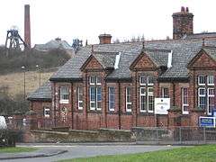 Anthony Bek School, with Pleasley Colliery in background |
|
 New Houghton |
|
| Population | 2,073 for Pleasley Parish (Census 2001) |
|---|---|
| OS grid reference | SK4965 |
| Civil parish | Pleasley |
| District | Bolsover |
| Shire county | Derbyshire |
| Region | East Midlands |
| Country | England |
| Sovereign state | United Kingdom |
| Post town | MANSFIELD |
| Postcode district | NG19 |
| Dialling code | 01623 |
| Police | Derbyshire |
| Fire | Derbyshire |
| Ambulance | East Midlands |
| EU Parliament | East Midlands |
| UK Parliament | Bolsover |
| Website | http://pleasleyparishcouncil.org.uk |
|
|
Coordinates: 53°10′55″N 1°15′11″W / 53.182°N 1.253°W
New Houghton is a small, rural, former coal-mining village in Derbyshire, England, 3 miles (4.8 km) from both Bolsover and Mansfield.
Governance
It lies within the civil parish of Pleasley. It is administered as part of the District of Bolsover. The area of Pleasley Parish Council includes Pleasley, New Houghton, Pleasley Vale and Stony Houghton.[1]
History
New Houghton was originally built in the 1890s to house workers from Pleasley Pit which was worked from 1874 until its closure in 1983,[2] when the remaining workable coal reserves were linked with and extracted via nearby Shirebrook Colliery.[3][4]
Education
The Pleasley and New Houghton school was erected in 1884, designed to accommodate 100 children. It is named Anthony Bek School, after a Lord of the Manor of Pleasley from 1293. Anthony Bek was also Bishop of Durham from 1283.[5] It is now a primary school, with secondary education available at Shirebrook Academy.[6]
Places of Worship
The village had a small church called Christ Church (now closed) on the Rotherham Road, next to the New Houghton Community Centre.
Village Amenities
- There is a combined village store and post office.
- The village had a public house called The Stanton (now closed and for sale during 2014).[7]
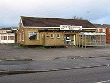
- The New Houghton Working Men's Club has occupied its present site in the centre of the village since 1957 (now closed).[8]
- The football team plays in a local Sunday league. Its home ground is the full-size football pitch adjacent to the Working Mans Club.
- Community Centre, next to the church, run by Pleasley Parish Council.
- Community House, near the village store (now closed).
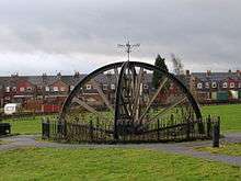
- New Houghton has a public open space – a Millennium Green, created to celebrate the new millennium of 2000 on a what used to be a rather overgrown, ugly site. This contains a pit head wheel, as a reminder of New Houghton's mining past, when most the men worked at the nearby Pleasley Pit. The Millennium Green has reverted to a rather overgrown site. A charitable trust was set up for the upkeep and maintenance of this green – New Houghton Millennium Green Trust, Charity Number 1072409, Date Registered 1998-11-12, Date Removed 2010-05-09.[9]
Transport
Roads
New Houghton is on the B6417 Pleasley to Clowne road. The village is separated from Pleasley (and bounded on its south-west side) by the A617 Chesterfield to Mansfield road.
Bus Services
As at January 2011, there are hourly commercial bus services during the daytime on weekdays from the village centre on the Rotherham Road (B6417) to Mansfield, Bolsover and Sheffield. There also half-hourly services to Mansfield and Chesterfield from bus stops on the A617 to the south-west of the village. Evening and Sunday services run less frequently and are subsidised by Derbyshire County Council.
Train Services
The local stations for Pleasley were closed in 1930 (Midland Railway) and in 1931 (Great Northern Railway).[10] The nearest stations are now Mansfield, and Chesterfield.
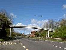
Footpaths and Trails New Houghton is linked to Pleasley via a footbridge over the A617. This then gives access to the longer-distance recreational routes of the Pleasley and Silverhill Trails.[11]
References
- ↑ "Pleasley Parish Council - About Us". Pleasley Parish Council. Retrieved 2011-01-30.
- ↑ "Pleasley Colliery History". J. S. Thatcher. Retrieved 2011-01-30.
- ↑ Shirebrook Colliery History Retrieved 2014-07-06
- ↑ Picture the Past Retrieved 2014-07-06
- ↑ "Pleasley Parish History". Pleasley Parish Council. Retrieved 2011-01-30.
- ↑ "Shirebrook Academy website". Shirebrook Academy. Retrieved 2011-01-30.
- ↑ Stanton Hotel for redevelopment Barnes auctions and property services. Retrieved 2014-08-09
- ↑ "New Houghton WMC". WMC Club Historians. Retrieved 2011-01-30.
- ↑ Open Charities Retrieved 2014-07-06
- ↑ Anderson, P. Howard (1973). Forgotten Railways: The East Midlands. David & Charles. ISBN 0-7153-6094-9.
- ↑ Pleasley and Teversal Trails Retrieved 2014-08-09