National Register of Historic Places listings in Emanuel County, Georgia
This is a list of properties and districts in Emanuel County, Georgia that are listed on the National Register of Historic Places (NRHP).
- This National Park Service list is complete through NPS recent listings posted December 16, 2016.[1]
Current listings
| [2] | Name on the Register | Image | Date listed[3] | Location | City or town | Description |
|---|---|---|---|---|---|---|
| 1 | James Coleman House | 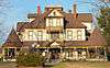 |
(#92000384) |
323 N. Main St. 32°36′07″N 82°20′11″W / 32.60186°N 82.33651°W |
Swainsboro | Built in 1904; now a Bed and Breakfast |
| 2 | Josiah Davis House | Upload image | (#82000145) |
South of Canoochee on GA 192 32°37′55″N 82°09′59″W / 32.63208°N 82.16633°W |
Canoochee | |
| 3 | Davis-Proctor House | 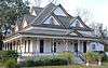 |
(#10001049) |
133 First Ave. 32°34′59″N 82°09′00″W / 32.58307°N 82.15013°W |
Twin City | Built in 1890, is a contributing property to the Twin City Historic District |
| 4 | Albert Neal Durden House | Upload image | (#90000561) |
Co. Rd. 360 32°34′19″N 82°13′26″W / 32.57200°N 82.22389°W |
Twin City | |
| 5 | Emanuel County Courthouse and Sheriff Department | Upload image | (#95000715) |
Main St. 32°35′48″N 82°20′03″W / 32.59654°N 82.33405°W |
Swainsboro | |
| 6 | First Methodist Episcopal Church | Upload image | (#99000160) |
Junction of Third Ave. and Third St. 32°26′29″N 82°12′50″W / 32.44127°N 82.21375°W |
Stillmore | |
| 7 | John Rountree Log House | Upload image | (#97000841) |
Junction of U.S. Route 80 and GA 192 32°35′03″N 82°09′53″W / 32.584167°N 82.164722°W |
Twin City | |
| 8 | Swainsboro Light and Water Plant | 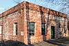 |
(#04001184) |
Bounded by East Moring and South Coleman Sts. and the Norfolk Southern Railway 32°35′48″N 82°19′52″W / 32.59665°N 82.33111°W |
Swainsboro | Built in 1921 |
| 9 | Twin City Historic District | 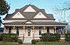 |
(#13001168) |
6th, Railroad & 5th Aves., Maple & College Sts. 32°35′01″N 82°09′02″W / 32.583486°N 82.150577°W |
Twin City |
References
- ↑ "National Register of Historic Places: Weekly List Actions". National Park Service, United States Department of the Interior. Retrieved on December 16, 2016.
- ↑ Numbers represent an ordering by significant words. Various colorings, defined here, differentiate National Historic Landmarks and historic districts from other NRHP buildings, structures, sites or objects.
- ↑ The eight-digit number below each date is the number assigned to each location in the National Register Information System database, which can be viewed by clicking the number.
| Wikimedia Commons has media related to National Register of Historic Places in Emanuel County, Georgia. |
| Topics | |
|---|---|
| Lists by states |
|
| Lists by insular areas | |
| Lists by associated states | |
| Other areas | |
| |
This article is issued from Wikipedia - version of the 8/18/2016. The text is available under the Creative Commons Attribution/Share Alike but additional terms may apply for the media files.