National Register of Historic Places listings in Elbert County, Georgia
This is a list of properties and districts in Elbert County, Georgia that are listed on the National Register of Historic Places (NRHP).
- This National Park Service list is complete through NPS recent listings posted December 16, 2016.[1]
Current listings
| [2] | Name on the Register | Image | Date listed[3] | Location | City or town | Description |
|---|---|---|---|---|---|---|
| 1 | Alexander-Cleveland House | .tif.jpg) |
(#77000423) |
3.5 mi. NE of Ruckersville 34°11′14″N 82°44′12″W / 34.187222°N 82.736667°W |
Ruckersville | |
| 2 | Ralph Banks Place | 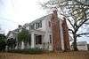 |
(#78000978) |
N of Elberton off GA 77 34°13′37″N 82°51′39″W / 34.226944°N 82.860833°W |
Elberton | |
| 3 | Bowman Commercial Historic District | Upload image | (#16000128) |
Public Square on GA 17 34°12′18″N 83°01′53″W / 34.205068°N 83.031366°W |
Bowman | |
| 4 | Building at 6 and 7 Public Square | Upload image | (#09000750) |
6 and 7 Public Square 34°12′18″N 83°01′54″W / 34.205106°N 83.031578°W |
Bowman | |
| 5 | Asa Chandler House | Upload image | (#82002409) |
1003 Old Petersburg Rd. 34°05′45″N 82°50′42″W / 34.095833°N 82.845°W |
Elberton | |
| 6 | Dove Creek Baptist Church | Upload image | (#87001154) |
GA 72 34°04′20″N 82°57′05″W / 34.072222°N 82.951389°W |
Elberton | |
| 7 | Elbert County Courthouse | 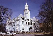 |
(#80001017) |
Courthouse Sq. 34°06′36″N 82°52′08″W / 34.11°N 82.868889°W |
Elberton | |
| 8 | Elberton Commercial Historic District | Upload image | (#82002410) |
Church, Elbert, Oliver, and McIntosh Sts., and Public Sq.; also N. McIntosh, Thomas, Church, & S. Oliver Sts. 34°06′35″N 82°52′04″W / 34.109722°N 82.867778°W |
Elberton | Second set of addresses represents a boundary increase July 14, 2015. |
| 9 | Elberton Depot | _Georgia_(image_3571).JPG) |
(#86002399) |
N. Oliver and Deadwyler Sts. 34°06′47″N 82°51′59″W / 34.113056°N 82.866389°W |
Elberton | |
| 10 | Elberton Residential Historic District | Upload image | (#82002411) |
Roughly bounded by Elbert, Oliver, Adams, Thomas, Edwards, and Heard Sts. 34°06′22″N 82°51′55″W / 34.106111°N 82.865278°W |
Elberton | |
| 11 | Forest Avenue Historic District | Upload image | (#15000102) |
Roughly bounded by Jones, Chestnut & W. Church Sts., Laurel & Oak Drs., Brookwood & Lake Forest Cirs., Forest & College 34°06′42″N 82°52′19″W / 34.111542°N 82.871903°W |
Elberton | |
| 12 | Ralph Gaines House | Upload image | (#77000422) |
N of Elberton on GA 368 34°12′09″N 82°48′32″W / 34.2025°N 82.808889°W |
Elberton | |
| 13 | Rock Gym | Upload image | (#98001559) |
45 Forest Ave. 34°06′39″N 82°52′19″W / 34.110833°N 82.871944°W |
Elberton | |
| 14 | Rucker House | Upload image | (#78000979) |
GA 985 34°09′49″N 82°47′22″W / 34.163611°N 82.789444°W |
Ruckersville |
Former listing
| [2] | Name on the Register | Image | Date listed | Date removed | Location | City or town | Summary |
|---|---|---|---|---|---|---|---|
| 1 | William Allen House | Upload image | (#75000591) | 9 mi. E of Elberton on SR 6 34°05′49″N 82°43′55″W / 34.096944°N 82.731944°W |
Elberton |
References
- ↑ "National Register of Historic Places: Weekly List Actions". National Park Service, United States Department of the Interior. Retrieved on December 16, 2016.
- 1 2 Numbers represent an ordering by significant words. Various colorings, defined here, differentiate National Historic Landmarks and historic districts from other NRHP buildings, structures, sites or objects.
- ↑ The eight-digit number below each date is the number assigned to each location in the National Register Information System database, which can be viewed by clicking the number.
| Wikimedia Commons has media related to National Register of Historic Places in Elbert County, Georgia. |
| Topics | |
|---|---|
| Lists by states |
|
| Lists by insular areas | |
| Lists by associated states | |
| Other areas | |
| |
This article is issued from Wikipedia - version of the 6/27/2016. The text is available under the Creative Commons Attribution/Share Alike but additional terms may apply for the media files.