Mount Hill, South Australia
| Mount Hill | |
|---|---|
| Korti Purre, previously Bluff Mount[1] | |
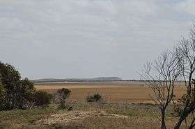
 Mount Hill, showing its bluff northern face, as viewed looking in a westerly direction from Lincoln Highway near Port Neill, at a range of about 20 km. | |
| Highest point | |
| Elevation | 450 m (1,480 ft) |
| Coordinates | 34°04′S 136°14′E / 34.067°S 136.233°ECoordinates: 34°04′S 136°14′E / 34.067°S 136.233°E |
| Geography | |
 Mount Hill | |
| Climbing | |
| First ascent |
20 April 1840 George Gawler, John Hill and Thomas Burr |
Mount Hill (Alternative name:Korti Purre, also previously known as Bluff Mount) is a prominent peak on the eastern side of southern Eyre Peninsula in South Australia. It is located within the locality of Butler.[1]
Geography
Mount Hill is the southern peak of a low range of hills lying along the eastern coast of Eyre Peninsula and is about 25 kilometres (16 mi) west of Spencer Gulf. At an elevation of about 450 metres (1,480 ft) above sea level, the isolated peak is a prominent landmark from the gulf. The surrounding country, originally very scrubby, has been mostly cleared for cropping. The nearest town is Port Neill. A railway siding located on the Eyre Peninsula Railway to the north-west of the hill has the name 'Mount Hill.'[2]
History
The first European to sight this peak was Matthew Flinders, who sailed past on 7 March 1802 and noted it in his log as 'a bluff inland mountain'[3] and on his chart as a 'bluff mount', alluding to the bluffness of its northern face.[4]
It was named Mount Hill on or about 20 April 1840 by Governor George Gawler when he was exploring this coast northwards on horseback from Port Lincoln accompanied by explorer and landholder John Hill and Deputy Surveyor General Thomas Burr. Their expedition was supported at sea by the brig Porter and the government cutter Water Witch. For the purpose of gaining a better view of the unexplored interior of Eyre Peninsula, Gawler and party ascended the peak, at which time it was named after John Hill.[5][6]
The party then proceeded northward past Mount Olinthus (which they also ascended and named) toward the Middleback Ranges, before returning to Franklin Harbour which Gawler also named and is at present, the site for the town of Cowell.[7]
The Water Witch and Porter parted there, the Porter returning to Port Lincoln with Gawler and the Water Witch to Adelaide via Point Riley, near Wallaroo. On 28 April 1840 near Point Riley Hill and Burr disembarked, the pair returning overland on horseback to Adelaide, thereby being the first Europeans to traverse northern Yorke Peninsula.[8][9]
The second recorded European exploration party to ascend Mount Hill was that of explorer Edward John Eyre, on 30 September 1840.[10]
A book titled In the Shadow of the Bluff gives a detailed account of the history of Mount Hill and the Hundred of Butler.[11]
Economy
The district economy has been primarily agricultural since European pastoralists first settled it in the 1840s, with grain cropping now being predominant.
References
- 1 2 3 "Search result for "Mount Hill (Mount)'" (Record no. SA0030421) with the following layers selected - "Suburbs and Localities" and " Place names (gazetteer)"". Property Location Browser. Government of South Australia. Retrieved 7 October 2016.
- ↑ "Search result for "Mount Hill Railway Station (RSAT)'" (Record no. SA0046922) with the following layers selected - "Suburbs and Localities" and " Place names (gazetteer)"". Property Location Browser. Government of South Australia. Retrieved 7 October 2016.
- ↑ Flinders, Matthew (1966) [1814]. A Voyage to Terra Australis : undertaken for the purpose of completing the discovery of that vast country, and prosecuted in the years 1801, 1802, and 1803 in His Majesty's ship the Investigator, and subsequently in the armed vessel Porpoise and Cumberland Schooner; with an account of the shipwreck of the Porpoise, arrival of the Cumberland at Mauritius, and imprisonment of the commander during six years and a half in that island. (Facsimile ed.). Adelaide; Facsimile reprint of: London : G. and W. Nicol, 1814 ed. In two volumes, with an Atlas (3 volumes): Libraries Board of South Australia. p. 241. Retrieved 4 January 2014.
- ↑ "Search result for "Bluff Mount (Mount)'" (Record no. SA0007755) with the following layers selected - "Suburbs and Localities" and " Place names (gazetteer)"". Property Location Browser. Government of South Australia. Retrieved 7 October 2016.
- ↑ "The Southern Australian. Quid perum atque decens curo, et roge, et omnts in hoc sum — HOR. EP., Hb. 1, ep 1, v 11. ADELAIDE: THURSDAY, APRIL 9, 1840.". Southern Australian. 9 April 1840. p. 3. Retrieved 4 January 2014.
- ↑ There cannot be the slightest doubt that Gov. Gawler named the hill after John Hill who was a member of the Governor's Party from Port Lincoln to Franklin Harbour., J.D. Somerville, 1943, SASR PRG 15/91/29.
- ↑ Gawler, George (16 May 1840). "GEOLOGICAL AND GEOGRAPHICAL NOTES ON THE PENINSULA OF "EYRIA," By His EXCELLENCY GOVERNOR, GAWLER, K.H.". South Australian Register. p. 6. Retrieved 4 January 2014.
- ↑ "EMIGRATION DEPOT. To the Editors of the South Australian Register. Adelaide, 2nd May, 1840.". South Australian Register. p. 5. Retrieved 4 January 2014.
- ↑ Roslyn M. Paterson and Eyvonne L. Price, From Stumps to Stubble : A history of the District of Bute (Adelaide, 1984), ISBN 0 85864 079 1, page pp.49–52.
- ↑ Edward John Eyre, Journals of Expeditions of Discovery (etc.) 1840–41, (London, 1845), Vol.1, p.152.
- ↑ In the Shadow of the Bluff. Published by the Butler Centenary Committee. ISBN 0 646 23548 6