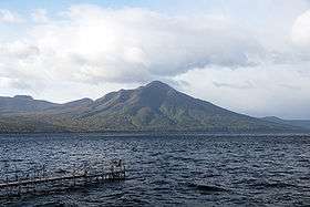
Mount Fuppushi
| Mount Fuppushi | |
|---|---|
| 風不死岳 | |
 Viewed from Lake Shikotsu | |
| Highest point | |
| Elevation | 1,102.6 m (3,617 ft) [1] |
| Listing | List of mountains and hills of Japan by height |
| Coordinates | 42°43′1″N 141°21′32″E / 42.71694°N 141.35889°ECoordinates: 42°43′1″N 141°21′32″E / 42.71694°N 141.35889°E |
| Geography | |
| Location | Hokkaidō, Japan |
| Topo map | Geographical Survey Institute (国土地理院 Kokudochiriin) 25000:1 風不死岳, 25000:1 樽前山, 50000:1 樽前山 |
| Geology | |
| Age of rock | Holocene |
| Mountain type | Stratovolcano |
| Volcanic arc/belt | Northeastern Japan Arc |
| Last eruption | 10 ka |
Mount Fuppushi (風不死岳 Fuppushi-dake) is dormant[2] volcano located in Shikotsu-Toya National Park in Hokkaidō, Japan. It sits adjacent to Mount Tarumae and opposite Mount Eniwa. Mount Fuppushi is on the south shore of Lake Shikotsu, the caldera lake that spawned the volcanoes.[3]
References
- ↑ Geographical Survey Institute website, 25000:1 maps 風不死岳 and 樽前山
- ↑ Paul Hunt, Hiking in Japan: An Adventurer's Guide to the Mountain Trails, pg. 179
- ↑ "Shikotsu". Global Volcanism Program. Smithsonian Institution.
- Paul Hunt, Hiking in Japan: An Adventurer's Guide to the Mountain Trails, Tokyo, Kodansha International Ltd., 1988. ISBN 0-87011-893-5 and ISBN 4-7700-1393-0 C0075
External links
- "Tarumaesan: National catalogue of the active volcanoes in Japan" (PDF). - Japan Meteorological Agency
- Fuppushi Dake - Geological Survey of Japan
| Wikimedia Commons has media related to Mount Fuppushi. |
This article is issued from Wikipedia - version of the 11/17/2016. The text is available under the Creative Commons Attribution/Share Alike but additional terms may apply for the media files.