Mont Turia
| Mont Turia | |
|---|---|
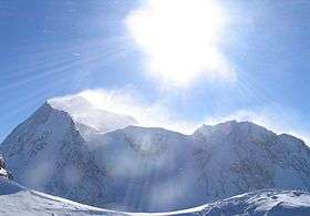 View from the north on the west ridge leading off Mont Turia. From left to right Mont Turia, Mont Pourri (in the back), Col des Roches (3,435 m), and Aiguille du St-Esprit (3,414 m). | |
| Highest point | |
| Elevation | 3,646 m (11,962 ft) |
| Prominence | 3 m (9.8 ft) [1] |
| Coordinates | 45°31′57″N 06°51′38″E / 45.53250°N 6.86056°ECoordinates: 45°31′57″N 06°51′38″E / 45.53250°N 6.86056°E |
| Geography | |
 Mont Turia France | |
| Location | Savoie, France |
| Parent range | Vanoise Massif |
Mont Turia is a shoulder on the north ridge of Mont Pourri in Savoie, France. It lies in the Massif de la Vanoise range. It has an elevation of 3,646 metres above sea level.
References
This article is issued from Wikipedia - version of the 11/28/2016. The text is available under the Creative Commons Attribution/Share Alike but additional terms may apply for the media files.