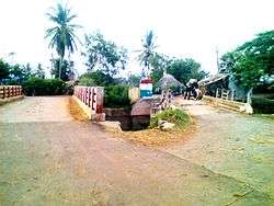
Modumudi
| Modumudi మోదుమూడి | |
|---|---|
| Village | |
 | |
 Modumudi  Modumudi Location in Andhra Pradesh, India | |
| Coordinates: 16°0′0″N 80°54′7″E / 16.00000°N 80.90194°ECoordinates: 16°0′0″N 80°54′7″E / 16.00000°N 80.90194°E | |
| Country |
|
| State | Andhra Pradesh |
| District | Krishna |
| Mandal | Avanigadda |
| Government | |
| • Type | Panchayat Raj |
| • Body | Gram panchayat |
| • MLA | Mandali Buddha Prasad |
| • MP | Konakalla Narayana Rao |
| Area[1] | |
| • Total | 13.76 km2 (5.31 sq mi) |
| Elevation | 11 m (36 ft) |
| Population (2011)[1] | |
| • Total | 4,256 |
| • Density | 310/km2 (800/sq mi) |
| Languages | |
| • Official | Telugu |
| Time zone | IST (UTC+5:30) |
| PIN | 521121 |
| Area code(s) | +91-8671 |
| Lok Sabha constituency | Machilipatnam |
Modumudi is a village in the Krishna district of Indian state of Andhra Pradesh. It is located in Avanigadda mandal of Machilipatnam revenue division.
Demographics
As of 2011 Census of India, Modumudi had a population of 4256 with 2490 households. The total population constitute, 2127 males and 2129 females with a sex ratio of 1001 females per 1000 males. 340 children are in the age group of 0–6 years, with a sex ratio of 969 per 1000. Child population constitute 7.99% of the total population. The average literacy rate stands at 73.32%, significantly higher than the state average of 67.41%.[2]
Transport
Modumudi is well connected by road. Auto services are available from Avanigadda APSRTC Bus Station to here. Distance is nearly 2 km from Avanigadda to here.
References
- 1 2 "District Census Handbook – Krishna" (PDF). Census of India. p. 16,472. Retrieved 8 January 2016.
- ↑ "Modumudi Census 2011".