Mmaku
| Mmaku Maku | |
|---|---|
| Nickname(s): Beauty of Wealth | |
| Country |
|
| State | Enugu State |
| LGA | Awgu |
| Population (2006 census) | |
| • Total | 256, 000 |
| Time zone | WAT (UTC+1) |
| 6-digit postal code | 402128 |
Mmaku is a town located in Awgu Local Government Area of Enugu State, Nigeria. Its prominent communities are Enugu Agu, Affam, Ifite and Ezioha. The Oji-Awgu road is the main thoroughfare in Mmaku. Surrounding communities are Ugbo, Obeagu, Mgbowo and Awgu.
Located between Obeagu and Awgu towns.[1]
History
There have been several myths related to the history of Mmaku.
One of them goes thus:
Anekemmadu is a hunter, he came to a land that is favourable for him and produces good yield and decided to live there with his wife Udumeogwee, his wife gave birth to 3 sons namely, Nnaka known now as Achi the first son, Ezianu known now as Mmaku the 2nd and Ogwunafor know now as Agwu the 3rd. Achi-nnaka the eldest decided to move to north of the land, Mmaku-Eziani retained his father's position and Ogwunafor move southward. The name MMAKU meaning welcomer or embracer, came to existence when the little boy embraced a spirit in form of human, due to his kind heart to welcome visitors, from there the name was given to him in addition to his real name Ezianu. Mmaku-Ezianu as he is called now got married and beget two sons, MMaku-Ukwu and Mmaku-Nta, and Mmaku-Nta beget 5 sons Enugu- Afam, Eziama, mkpurumkpu, Awo, Agboneri, and Mmaku-Ukwu beget 7 sons namely Amanato, Ezioha, Amegu, Enugu-Agu, Okwuluofia, Otokwu,and Ifite.
The other goes like this:
The literal English meaning of the name, Mmaku, is 'Beauty of Wealth'. According to historical and oral evidences, Mmaku was a 4th generation descendant of Nri (the son of Eri, the son of Gad, the son of Jacob (Genesis Chapter 30:9; 46: 16 and Numbers chapter 26:15-19) the acclaimed ancestor of the Igbo Race of the South East Nigeria who migrated southward after the Jewish Exodus from Egypt and migrated towards south of Sudan.
Eri had two wives namely Nneamaku and Oboli. Nneamaku had five children namely Nrifikwuanịm-Menri, his first son, Agụlụ, Ogbodudu, Onogu and Iguedo her only daughter. Nri-Ifikwuanịm beget Agụkwu Nri, Enugwu-Ukwu, Enugwu-Agidi, Nọfịa, and Amọbia. Nri-Ifikwuanim was a Priest like his father Eri. Eri had continued the Jewish traditional worship even as he settled at Ezunaoamambala (hence Anambra).
Nri-Ifikwuanim being the first child/son of Eri continued to establish and strengthen the kingdom of his father. He was the custodian of the tradition and the Royal Priest. Having begotten five children from his first wife, he continued to have more children from his other wives and concubines. His kingdom was quick to expand.
However, when he passed-on to his ancestors, his entire family could not hold anymore as one, some of the sons left with their families and migrated to the east and south, none migrated north or west. Those that left continued with their father's traditions like the 'Igu-Aro' (observing the yearly calendar) child circumcision and many more rites.
Ezianu, a grandchild of Eri-Ifikwuanim the son of Nneamaku, begot Mmaku, a twist of the suffix in his great grand mother's name, Nneamaku (Mother of the place of wealth). Ezianu (good land) arrived at the green belt after Awka (Oji/Awgu location) and he was so blessed and became so rich that he blessed the god of his ancestors for bringing him to the place and named it 'ezi-anu'. He founded a dynasty after his name, named his first son Mma-Aku (beauty of wealth) and believed strongly that the name of his great grandmother, Nneamaku, has influenced him to become wealthy. Ezianu settled and beget other children including Mmaku as the first son, Achi, Mgbowo, Nkwe, Ezere, Mgbidi, Awgu, and Awgu-nta. It has been confirmed that Ezianu migrated from the present day Amoli. The possibility of blood link with Amoli is till been investigated.
When Ezianu passed-on, Mmaku retained the ancestral and spiritual custodian of the Ezi-anu Clan. Achi, who migrated northward of the Mmaku home, became friendly with other migrated descendants of Eri located at the west of Oji River hence the high influence of the cultures of the neighbors on its original cultures as could be observed today.
Mmaku, the first son of Ezi-anu begot 12 children named, Afam (Enugu Afam, the traditional and spiritual custodian of Ezi-anu deity), Eziama, Ibite, Mkpulukpu, Awo, Ezioha, Otokwu, Amanato, Okwulofia, Amegu, Enugwu-Mmaku and Ifite-ohanta. Some of the descendants of Mmaku also migrated to Arochukwu, today called Mmaku-Aro. Some of the descendants of Ezioha and Amanato migrated to Mgbowo to become what is today called Amanato and Ezioha Mgbowo while some descendants of Okwulofia migrated to Ogwugwu from where is called Ebo-Ogwuwgu.
The ancestral shrine of Mmaku is situated at the family house of Ezi-anu called Ezi-anu Shrine located at Enugwu Affam. Kings are crowned at this location considered the most sacred spot in Mmaku. Till date, the dialect of Mmaku never changed from that of his grand-cousins and brothers in Nofia, Amobia, Enugwu-Agidi, Enugu-Ukwu and Agukwu-Nri. According to Eri, his generational first sons must keep to his (Eri) traditions and one of such is the language.
Spirituality
Due to the continuous upholding of the ancestral Eri traditions, Mmaku has continued to be a great place of spiritual revival. It has produced great Christian preachers and ministers; examples are the renowned songwriter and singer Rev Patty Obasi, South African based Radio Evangelist, Rev Ayobanna Ikeanumba and Rev Fr. James Ani (whom was once alleged to have incited his followers to beat policemen).[2]
Culture
Geography
Vegetation[3]
Mmaku is located in south-eastern Nigeria, which consists of main rain forest vegetation and few savannah vegetation. The rain forest vegetation in Mmaku consists of mainly of trees with some shrubs, grasses and climbers. The vegetation in Mmaku and its environs is thick during the rainy season and sparse during the dry season or Harmattan.[3]
In Mmaku and its environs, rainforest vegetation is assisted by the low land and deep gullies. This is because of the softness of the soil which supports the growth of luxuriant trees such as found mainly along Mmaku-Oweli road and in the foot plains in Mmaku.[3]
Savannah vegetation also occurs in Mmaku and its environs. By definition, savannah vegetation is the type of vegetation which consists mainly of grasses and few shrubs and trees. In Mmaku-Owelli-Amolli area, savannah vegetation occurs in the hills in the area. This is because those hills consists of hard rocks which did not support the growth of luxuriant trees but it support the growth of shallow rooted plants mainly grasses.
Generally, Mmaku and its environs consist of few main types of vegetation which are rainforest vegetation and Savannah vegetation. The rain forest vegetation is associated with low land in Mmaku and its environs while the Savannah vegetation are associated with the hills in the area.
The vegetation in Mmaku and its environs are thick during the rainy season and sparse during the dry season except at the river bank and stream beds or banks in the area.
Climate
The study area is part of equator which is located at in the Greenwich Meridian. The equator location of the study area made it to have equatorial climate. The temperature in the study area are high throughout the year except during the harmattan.
The rainfall in the study area are high. It occur mainly in form of orographic rainfall, frontal rainfall, and relief rainfall. The rainfall in the study area are associated with strong wind and thunderstorm. The rainfall in the study area starts mainly from the months of April to September or October and sometimes November. The rainfall in the study area decreases towards August which is known as August break. The humidity in the study area are high during the rainy season. The harmattan in the study area starts from the month of November or sometimes December till the January or February of the coming year.
The atmospheric pressure in the study area are high mainly at the mountainous region in the area which are mainly in Mmaku plateau and many elevated area around Nkwe-Ugbookpara area. The atmospheric pressure in the mountainous regions of Mmaku and its environ are about 880 to 960 mmhg (Iloege, 1992).[4] The atmospheric pressure in the low land, in Mmaku and its environ are about 760mmhg to 780mmhg.
Rainfall distribution in Mmaku and its environ are highly affected by the atmospheric pressure and by vegetations in the area.
Topography
Mmaku and its environs consist of rough elevated topography. The rough topography in Mmaku and its environ indicated different in the homogeneity of rock hardness.
The elevated area in Mmaku-Nkwe-Obeagu and ugbokpara are consists of hard rocks which are highly lithfied and compacted. The highly lithified and compacted rocks resists weathering which makes them to form elevated area while the low land area in Mmaku and its environ consist of soft rock in Mmaku-Nkwe-Amolli-Owelli-obiagu and Ugbokpara had been termed syncline or syclinorium by early workers among them are (Benkhill 1986; Obi et al., 1991 & Uma et al., 1993).
Drainage
The study area Mmaku and its environ are sedimentary environment. It consist of tendritic pattern of drainage system which flow in southeast ward with other distributaries joining it. The drainage system in the study area are conspicuous during the rainy season and sparse during the dry season because of the dying up of some of the streams.
The streams in Mmaku which is at the border between Mmaku and Owelli flows south-eastward were they joined Enugu River which flow southward.
Soil
Soil type in Mmaku and its environs consist mainly of sandy soil, clay soil and with small amount of sandy-clay, silt soil and humus soil. The sandy soil covers many places in Mmaku and its environs. The sandy soil in Mmaku and its environs display mainly facies from highly compacted sandy shale to poorly compacted sandy soil and from well sorted sandy soil and from highly ferroginised sandy soil to medium ferroginised then to unferroginised sandy soil. The poorly compacted sandy soil in Mmaku area is found along Mmaku-Owelli road while the highly compacted soil in Mmaku is found along Mmaku-Nkwe-Obeagu-Ugbokpara road.
The clay soil in Mmaku are abundantly occur in Amolli-Mmaku road. The clay soil in Mmaku and its environ are dark and bulky while some are earthly brown. Most of the clay soil in Mmaku and its environs are covered by hard lateritic layers which formed by the ferroginisation and lithification of the surface of the clay.
Silt soil occurs abundantly along Amolli-Nkwe-Mmaku gulley erosional site. The siltstones or soil in the area are light to brown coloured while some are dark coloured. The silt stone along Mmaku-Owelli area display concretion.
Sandy clay soil also occur in Mmaku in Obeagu and Ugbopkara are, the sandy clay in Mmaku occur in places where there are contact between shale and sandstone.
Humus soil in Mmaku and its environs capped many soil in the area. Humus soil occur in forested areas in Mmaku where they formed by decaying of plants materials on the surface of the soil. Humus soil in the study area are dark coloured.
Population
According to 2006 Census, the population of Mmaku is 256, 000 people consisting of more women than men.
Economy
Mmaku is surrounded by streams hence the perennial production of vegetables and tubers. Agriculture remains the main economic strength of the people. Mmaku has a weekly Afor market located at Affam community.
Landmarks
Mmaku is also a tourist site with various tourist attraction centres such as:
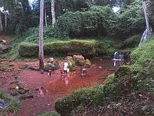
- Ishi Mmam (Where Mmamu River has its source).
- Omoo Stream in Afam-Mmaku
- Ogba n' aza oku (Echoing Cave)
- St Philips Anglican Church (Archdeaconry), Enugu-Mmaku[5]
- St Theresa Catholic Church, Ezioha-Mmaku[6]
- ST. JOHN'S PARISH, OTOKWU-MMAKU[7]
Another landmark achievement of Mmaku is the successful hosting of Gulder Ultimate search 5
Hotels
According to Jumia Travel,[8] there are four (4) prominent Hotels in Mmaku, namely:
- Pat Benson's Green Valley Suites
- Maco Plaza Hotel
- Village Gate
- Nice & Cool Hotel
Education
Secondary School
- Mmaku High School, formally Boys' High School, Mmaku[9]
- GIRLS' SECONDARY SCHOOL MMAKU (formally Girls High School, Mmaku)[10]
- Community Secondary School, Mmaku[11]
- St. Theresa Secondary School (Mmaku Catholic Centre)
Primary School
- Central School, Mmaku
- Community (primary) School, Enugu-Mmaku,
- Udechukwu Memorial School, Ifite,
- Primary School, Otokwu
- St. Theresa Nursery and Primary School (Mmaku Catholic Centre)
People from Mmaku
- Prof. Mark Anikpo[12]
References
- ↑ "Google Maps". Google Maps. Retrieved 2016-09-24.
- ↑ Ani, JusticeforFatherJames. "Impasse at Mmaku Catholic Church, Nigeria". Retrieved 2016-09-24.
- 1 2 3 "GEOLOGY OF MMAKU AND ITS ENVIRONS IN AWGU LOCAL GOVERNMENT AREA, ENUGU STATE NIGERIA N6000". legacytechnologies.biz. Retrieved 2016-09-24.
- ↑ "GEOLOGY OF MMAKU AND ITS ENVIRONS IN AWGU LOCAL GOVERNMENT AREA, ENUGU STATE NIGERIA N6000 | Raynold Egbuna - Academia.edu". academia.edu. Retrieved 2016-09-23.
- ↑ "Google Maps". Google Maps.
- ↑ "Google Maps". Google Maps. Retrieved 23 November 2016.
- ↑ "Awgu Region". www.awgudiocese.org.
- ↑ "4 hotels in Mmaku, Nigeria". Jumia Travel.
- ↑ Enugu, Public Relations Unit, PPSMB. "MMAKU HIGH SCHOOL MMAKU :: PPSMB Enugu". www.ppsmbenugu.com.ng.
- ↑ Enugu, Public Relations Unit, PPSMB. "GIRLS' SECONDARY SCHOOL MMAKU :: PPSMB Enugu". www.ppsmbenugu.com.ng.
- ↑ Enugu, Public Relations Unit, PPSMB. "COMMUNITY SECONDARY SCHOOL MMAKU :: PPSMB Enugu". www.ppsmbenugu.com.ng.
- ↑ Anikpo, Mark. "https://www.linkedin.com/in/professor-mark-anikpo-20a65b77". LinkedIn. External link in
|title=(help)