Mito, Aichi
This article is about the town in Aichi Prefecture, Japan. For the capital city of Ibaraki Prefecture, see Mito, Ibaraki. There are two towns with names written identically in Japanese in two other prefectures; see Mitsu, Hyogo and Mitsu, Okayama.
| Mito 御津町 | |
|---|---|
| Former municipality | |
|
Mito Town Office | |
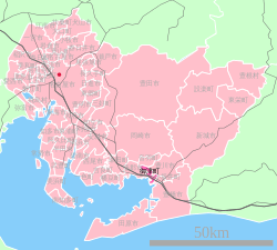 Location of Mito in Aichi Prefecture | |
 Mito Location in Japan | |
| Coordinates: 34°49′N 137°19′E / 34.817°N 137.317°ECoordinates: 34°49′N 137°19′E / 34.817°N 137.317°E | |
| Country | Japan |
| Region | Chūbu (Tōkai) |
| Prefecture | Aichi Prefecture |
| District | Hoi |
| Merged |
January 15, 2008 (now part of Toyokawa) |
| Area | |
| • Total | 18.73 km2 (7.23 sq mi) |
| Population (November 1, 2007) | |
| • Total | 13,536 |
| • Density | 722.69/km2 (1,871.8/sq mi) |
| Symbols | |
| • Tree | Japanese Black Pine |
| • Flower | Dwarf azalea |
| Time zone | Japan Standard Time (UTC+9) |
| Website | City of Toyokawa |
.jpg)
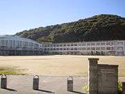
Mito Junior High School
.jpg)
Mito High School
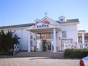
Aichi-Mito Station
Mito (御津町 Mito-chō) was a town located in Hoi District, Aichi Prefecture, Japan.
On January 15, 2008, Mito, along with the town of Otowa (also from Hoi District), was merged into the expanded city of Toyokawa.
As of 2007 (the last data available prior to the merger), the town had an estimated population of 13,536 and a population density of 722.69 persons per km². The total area was 18.73 km².
History
The area around Mito has been settled since prehistoric times, and archaeologists have found numerous remains from the Jomon, Yayoi and Kofun periods.
- 1930: Mito Town was founded.
- 1939: Symbol of Mito was adopted.
- 1947: Mito Junior High School was founded. Goyu Station changed its name to Aichi-Mito Station.
- 1976: New town office was completed.
- 1979: Crematory was completed.
- 1980: Ceremony to celebrate the 50th anniversary of the founding of Mito Town was held.
- 1986: Mito High School was founded.
- 1992: Mt. Mito promenade (御津山遊歩道) was completed. Water purification plant was completed.
- 1995: Heartful Hall was completed.
- 1996: The first Mito Festival (みとまつり Mito Matsuri) was held.
- 2000: Welfare and Health Center opened.
- October 2, 2007: Mito Town Library opened in the Heartful Hall.
- January 15, 2008: Mito Town, along with Otowa Town (also from Hoi District), was merged into the expanded Toyokawa City.
Region
Education
Primary schools
- Mito Nanbu Primary School
- Mito Hokubu Primary School
Junior High school
- Mito Junior High School
High school
- Mito High School (御津高校)
Social education
Ceremony Hall
- Heartful Hall
Library
- Mito Town Library
Transportation
Railway
- Central Japan Railway Company
- Nagoya Railroad
- Meitetsu Nagoya Main Line - Odabuchi Station (This station is located in Toyokawa, but it is near to Kamisawaki, Mito)
Road
Bus
- Meitetsu Tohbu Kanko (Sunrise Bus) - Toyohashi Line
Local attractions
- Daionji Temple (大恩寺)
- Mt. Mito (御津山)
- Miyukihama (御幸浜)
- Ruins of the Takemoto Castle (竹本城址)
- Mikawa Coastal Green Tract (三河臨海緑地)
- Mikawa-Mito Marina (三河御津マリーナ)
Noted persons from Mito
- Kayoko Ohara (小原 佳代子) - Nankai Broadcasting's announcer
External links
![]() Media related to Mito, Aichi at Wikimedia Commons
Media related to Mito, Aichi at Wikimedia Commons
- Toyokawa Official website (Japanese)
This article is issued from Wikipedia - version of the 9/4/2015. The text is available under the Creative Commons Attribution/Share Alike but additional terms may apply for the media files.