Middle Magdalena Basin
| Middle Magdalena Basin | |
|---|---|
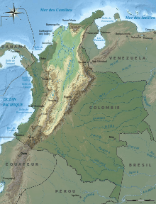 The Middle Magdalena Basin is located between the Central and Eastern Cordilleras of the Andes Mountains in Colombia.[1] |
The Middle Magdalena Basin is an intermontane basin located in northwestern Colombia between the Central and Eastern Cordilleras of the Andes Mountains.[1] It is structurally bounded by the Palestina Fault to the west and the Bucaramanga Fault to the east.[1] The basin is part of the Magdalena Valley which includes the Upper Magdalena Basin to the south and Lower Magdalena Basin to the northwest of the Middle Magdalena Basin.[2] The basin elongate in that it is only approximately 80 km wide but extends to the north approximately 450 km where it terminates against the Santander Massif and Cesar Valley.[2] To the south it terminates against the Upper Magdalena Basin, which consists of the Girardot and Nieva sub basins where the Central Cordillera and Eastern Cordillera converge.[3]
Basin development
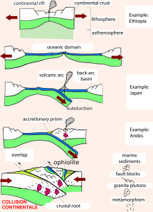
During the Jurassic period, Pangea began to pull apart causing separation of North America from South America.[3] This rifting produced a subduction zone where the Nazca plate was subducting to the east under the South American plate. Part of this subducting plate was the Baudo-Island Arc separated from the South American continent by the marginal Colombian Sea.[2] The formation of the extensional back-arc basin associated with this subduction is the origin of the Middle Magdalena Basin in the late Jurassic.[2] Throughout the Cretaceous, the basin experienced thermal subsidence and five transgressive-regressive cycles as part of a marine megacycle.[2][3]
In the Paleocene, the rate of subduction increased causing the marginal Colombian Sea to close and the Baudo-Island Arc to collide with the South American continent.[2] This caused accretion of the Western Cordillera and uplift of the Central Cordillera transforming the back-arc basin into the pre-Andean foreland basin.[1][2][3] Around the time of the Oligocene, the Nazca plate increased its subduction to the east while the South American plate experienced a westward pull.[4] This caused the Andean orogeny in the Miocene and uplift of the Eastern Cordillera in the Pliocene.[1] Now the Middle Magdalena basin is an intermontane basin situated between the uplifted Central and Eastern Cordilleras.[1]
Geologic structures
Faulting in the Middle Magdalena Basin is primarily reverse and thrust faulting.[3] Reverse faulting is high angle in the west and low angle in the eastern and central areas of the basin with normal faults also developing along the eastern margin. These thrust faults formed from thrusting from the eastern margin of the Central Cordillera in the Eocene and the western margin of the Eastern Cordillera in the Miocene.[3] The major thrust faults in the Middle Magdalena Basin include the Infantas thrust,[3] La Salina thrust,[5] and Cantagallo thrust fault.[5] The basin is structurally bounded by the Palestina fault, a dextral strike slip system, in the west and the Bucaramanga fault, a sinistral strike slip system, in the east.[1]
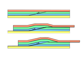
The major surface structures of the Middle Magdalena Basin are asymmetric synclines and basement cored anticlines which formed as a result of thrusting from the Eastern Cordillera and Central Cordillera. The thrusting initiated faulting in the Pre-Mesozoic basement. The faults then pushed through the Jurassic layers to the Cretaceous ductile stratigraphy. The faults then form horizontally at the ductile-brittle transition for 10–20 km before cutting through the upper brittle stratigraphy. The resulting structure is a syncline against the hanging wall of the fault next to an inclined anticline.[3] Key folds in the basin for hydrocarbon exploration include the Nuevo Mundo and Guaduas syncline.[3] As suggested by the formation of the folds, both of these synclines are bounded by thrust faulting and anticlines.[3][6]
Stratigraphy

The stratigraphy of the Middle Magdalena Basin can be divided into three sequences separated by angular unconformities.[1] The basement of these sequences is Pre-Mesozoic metaclastics and sediments which are now exposed on the surface of the Central Cordillera as a result of its deformation and uplift.[3] This geologic basement is at most 15 km deep with faulted sections shifted up to approximately 10 km in depth.[7] The unconformity that separates the basement from the first sequences indicates the approximate time rifting began.
First sequence
The first sequence was deposited in the Jurassic during the rifting which caused the initial formation of the basin. This Jurassic formation is called the Giron group which consists of siltstones and rhyolitic tuffs.[1] During this period, the basin also experienced granitic plutonism along its western margins.[2][3] The Jurassic-Cretaceous angular unconformity separating the first and second sequence is representative of the post-rift boundary.[1]
Second sequence
The middle sequence represents the formations deposited throughout the Cretaceous and early Paleocene.[1] The oldest formations in this sequence are the Tambor and Los Santos formations of conglomerates and sandstones indicate a continental to fluvial depositional environment.[1] In the early Cretaceous, the sea level began to rise and formed a shallow marine environment with siltstone and shale deposits in the Cumbre formation.[1][2] The sea level continued to rise throughout the middle Cretaceous when the Tablazo and Salto limestones and Simiti shale were deposited.[3] The La Luna formation represents the peak of the sea level with deep marine deposits of limestone, chert, and shale.[1] The sea level then began to fall returning the environment to shallow marine with deposition of the Umir formation of shales and sandstones.[1] Finally, the Paleocene saw the deposition of the Lisama formation of deltaic mudstones and sandstones.[1] This entire middle sequence indicates a marine megacycle consisting of five transgressive-regressive cycles.[3] The angular unconformity between the second and third sequences is a result of erosion from the accretion of the Western Cordillera.[1]
Third sequence
The final sequence represents deposition from the early Tertiary to present day.[1] Within this sequence there are three subsequences that are a result of deformation and uplift of the Central and Eastern Cordilleras.[3] The first subsequence consists of the Chorro group with the La Paz and Esmeraldas formations and the Chuspas group with the Mugrosa and Colorado formations all deposited during the Eocene-Oligocene.[3] These groups consist of fluvial sandstones, mudstones, siltstones, and shales and are a result of erosion fn the Central Cordillera.[1][3] The second subsequence is the Miocene Real formation consisting of fluvial sandstones and conglomerates.[1] Similar to the Real formation, the final subsequence is the Pliocene Mesa formation, which is composed of sandstones and conglomerates deposited from the Eastern Cordillera uplift.[3] On the surface of the basin are Pleistocene alluvial fan deposits.[3]
Petroleum resources
The primary reservoirs in the Middle Magdalena Basin are fluvial sandstones and conglomerates from the Churro and Chupas groups which have 20-25% porosity and 0.5-1 d permeability.[3] The main source of hydrocarbons is the La Luna limestone with a total organic carbon of 3-4% and type II marine kerogen sealed by overlying Eocene shales.[3] There are three types of traps that house hydrocarbons in the Middle Magdalena Basin. The two structural traps are large anticlines in the center of the basin and smaller anticlines along the western margin. Both of these anticlinal traps produce from Tertiary sandstones within the Churro and Chuspas groups. The third trap is stratigraphical with the La Luna limestone sealed by overlying shales.[3]
Primary fields
| Field name | Producing Formations | Producing Stratigraphy | Structure |
|---|---|---|---|
| La-Cira Infantas | Colorado, Mugrosa, La Paz | Sandstone, conglomerate, shale | Dome bounded by Infantas thrust |
| Casabe | Colorado, Mugrosa, La Paz | Claystone, sandstone | Fault bounded |
| Cantagallo | La Paz, Esmeraldas | Sandstone, claystone, shale | Fault bounded |
| Velasquez | Tune, Avechucos | Claystone, siltstone, sandstone | Bounded by normal faults |
The table above shows some of the largest producing fields. Included is their producing formation, the stratigraphy of that formation, and the structure of the field that is housing the hydrocarbons. The Tune and Avechucos formations are equivalent to the Chorro and Chuspas groups. Both the Casabe and Cantagallo fields are located on the Magdalena River towards the western margin of the basin with the Cantagallo fields located approximately 40 km north of the Casabe field. Approximately 30 km east of the Casabe field is the oldest and largest La-Cira Infantas field towards the central to eastern margin of the basin. The Velasquez field is located at the southern end of the basin near the Upper Magdalena Basin.[8]
Current exploration is focused in the southern area of the basin where heavy amounts of faulting could house potential hydrocarbons. Aside from the La Luna limestone, other potential source rocks include early Cretaceous sediments such as the Paja or Simiti shale or the late Cretaceous Umir shale.[6]
References
- 1 2 3 4 5 6 7 8 9 10 11 12 13 14 15 16 17 18 19 20 21 Cubillos, Flavio. "Structural Analysis of an Area in the Northern Central Part of the Middle Magdalena Basin, Colombia". Colorado School of Mines. Retrieved 8 February 2015.
- 1 2 3 4 5 6 7 8 9 Cooper, M.A.; Addison, F.T.; Alvarez, R.; Coral, M.; Graham, R.H.; Hayward, A.B.; Howe, S.; Martinez, J.; Naar, J.; Penas, R.; Pulham, A.J.; Taborda, A. (October 1995). "Basin Development and Tectonic History of the Llanos Basin, Eastern Cordillera, and Middle Magdalena Valley, Colombia". AAPG Bulletin. 79 (10): 1421–1443. doi:10.1306/7834d9f4-1721-11d7-8645000102c1865d.
- 1 2 3 4 5 6 7 8 9 10 11 12 13 14 15 16 17 18 19 20 21 22 23 Schamel, Steven (1991). "Upper and Middle Magdalena Basins, Colombia". Active Margin Basins (Memoir). AAPG Special Volumes. pp. 281–301.
- ↑ Husson, Laurent; Conrad, Clinton P.; Faccenna, Claudio (2012). "Plate motions, Andean orogeny, and volcanism above the South Atlantic convection cell". Earth and Planetary Science Letters. 317-318: 126–135. Bibcode:2012E&PSL.317..126H. doi:10.1016/j.epsl.2011.11.040.
- 1 2 Moreno, Christopher J.; Horton, Brian K.; Caballero, Victor; Mora, Andres; Parra, Mauricio; Sierra, Jair (2011). "Depositional and provenance record of the Paleogene transition from foreland to hinterland basin evolution during Andean orogenesis, northern Middle Magdalena Valley Basin, Colombia". Journal of South American Earth Sciences. 32: 246–263. doi:10.1016/j.jsames.2011.03.018.
- 1 2 3 Moretti, Isabelle; Rodriguez Charry, German; Mayorga Morales, Marcela; Mondrago, Juan Carlos (2010). "Integrated exploration workflow in the southern Middle Magdalena Valley (Colombia)". Journal of South American Earth Sciences. 29: 187–197. doi:10.1016/j.jsames.2009.08.011.
- ↑ Sanchez, Carlos Javier (2011). "http://repositories.lib.utexas.edu/handle/2152/ETD-UT-2011-08-4185". UT Electronic Theses and Dissertations. External link in
|title=(help) - 1 2 Luis G. Morales; Colombian Petroleum Industry (1958). "General Geology and Oil Occurrences of Middle Magdalena Valley, Colombia". In Weeks, Lewis G. SP 18: Habitat of Oil. Tulsa, OK: AAPG. pp. 641–695.