Matekane Air Strip
| Matekane Air Strip | |||||||||||
|---|---|---|---|---|---|---|---|---|---|---|---|
 | |||||||||||
| IATA: MTK – ICAO: FXME | |||||||||||
| Summary | |||||||||||
| Airport type | Public | ||||||||||
| Owner | Government of Lesotho | ||||||||||
| Elevation AMSL | 7,544 ft / 2,299 m | ||||||||||
| Coordinates | 29°55′45″S 27°50′54″E / 29.92916°S 27.84822°ECoordinates: 29°55′45″S 27°50′54″E / 29.92916°S 27.84822°E | ||||||||||
| Map | |||||||||||
 MTK Location within Lesotho | |||||||||||
| Runways | |||||||||||
| |||||||||||
|
Source: Google Maps[1] | |||||||||||
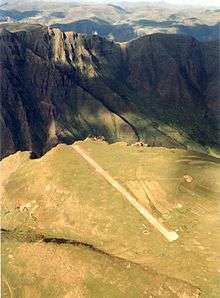
Matekane Air Strip is an airport in Lesotho, Africa with a 400 m (1,300 ft) runway that extends to the edge of a 600 m (2,000 ft) cliff. The airport, which is owned by Sam Matekane of Matekane Group of Companies, is often used by charity organizations and doctors to access remote villages in the area, and is labeled as having one of the world's scariest runways.[2]
See also
- Transport in Lesotho
- List of airports in Lesotho
 Aviation portal
References
- ↑ Google Maps - Matekane
- ↑ Farhad Heydari (October 2009). "The World's Scariest Runways". Travel & Leisure. Retrieved 12 February 2011.
This article is issued from Wikipedia - version of the 11/9/2016. The text is available under the Creative Commons Attribution/Share Alike but additional terms may apply for the media files.