Marjah
| Marjah مارجه | |
|---|---|
|
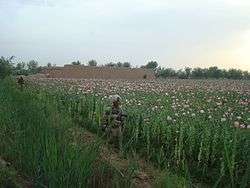
U.S. Marines on a patrol next to a poppy field in 2010 | |
 Marjah Location in Afghanistan | |
| Coordinates: 31°31′N 64°07′E / 31.517°N 64.117°E | |
| Country | Afghanistan |
| Province | Helmand Province |
| District | Nad Ali |
| Occupation |
|
| Population [1][2][3] | |
| • Total |
80-85,000 (disputed) 125,000 (with surrounding area - also disputed) |
| Time zone | UTC+4:30 |
Marjah (also spelled Marjeh; Pashto/Persian: مارجه ) is an agricultural town in southern Afghanistan. It has a population between 80,000 and 125,000 and is spread across 80 to 125 km², an area larger than Cleveland or Washington, D.C.[4] The town sits in Nad Ali District of Helmand Province, southwest of the provincial capital Lashkar Gah. There are some unconfirmed reports that Marjah is planned to be turned into a separate district.
Population and economy
Marjah is geographically situated in one of Afghanistan's major belts of poppy fields,[5] which are a source of funds for the Taliban.[6] According to one figure, 10% of global illicit opium production in the year 2000 originated from the Marjah/Nad-i-Ali area.[7] During the 1950s and 1960s the United States funded a scheme, run by the Helmand and Arghandab Valley Authority, to irrigate the fields around Marjah (Lashkar Gah/Helmand was nicknamed "Little America"), with many canals remaining to this day.[1][6]
In conjunction with this American-led development, which included building and staffing a number of local schools, the Afghan government jump-started a program in 1959 to resettle Pashtun nomads to the area, providing them each with "almost 15 acres of land, two oxen and free seeds", with a focus on growing wheat.[8] Besides facing a number of technical problems,
Climate
Data collected in the 1950s in the Marjah/Chah-i-Anjirs area showed an average rainfall of over one inch per month from December through March, peaking in January at 2.46 inches. The rest of the year experienced little or no precipitation, and besides January, there was actually a consistent net loss of water through evaporation. June, July, and August experienced average high temperatures of over 100 °F (38 °C), while the average lows in winter bottomed out at just above freezing in December and January.[9]
See also
- Marjah Accelerated Agricultural Transition (2010 project)
References
- 1 2 Thompson, Mark (2010-02-09). "U.S. Troops Prepare to Test Obama's Afghan War Plan". TIME. Retrieved 2010-02-09.
A town of 80,000, Marja...
- ↑ Perry, Tony (2010-02-03). "In Afghanistan, Marines ready attack on Taliban redoubt". Los Angeles Times. Retrieved 2010-02-03.
Marja, with a population estimated at 85,000...
- ↑ Marquez, Miguel (2010-02-03). "Afghanistan: Marines Gear Up for Biggest Fight Yet". ABC News. Retrieved 2010-02-03.
Marja and the surrounding area, with an estimated population of 125,000...
- ↑ Gareth Porter, Inter Press Service, 8 March 2010, Fiction of Marjah as City Was U.S. Information War
- ↑ Nordland, Rod (2010-02-03). "Military Officials Say Afghan Fight Is Coming". The New York Times. Retrieved 2010-02-03.
- 1 2 Perry, Tony (2010-01-31). "Marine assault vehicles key to Afghan strategy". Los Angeles Times. Retrieved 2010-02-04.
- ↑ Hafvenstein, Joel (2007). Opium Season: A Year on the Afghan Frontier. Globe Pequot. p. 157. ISBN 1-59921-131-9.
- ↑ Chandrasekaran, Rajiv (2010-02-10). "Marines plan joint mission to eject insurgents from last Helmand stronghold". The Washington Post. Retrieved 2010-02-10.
- ↑ Michel, Aloys Arthur (1959). The Kabul, Kunduz, and Helmand Valleys and the national economy of Afghanistan: a study of regional resources and the comparative advantages of development. National Academies. pp. 142–145.
| Wikimedia Commons has media related to Marjah, Afghanistan. |
Further reading
- Gareth Porter. "Marjah: The Non-Existent City the Military Said We Conquered in Afghanistan". AlterNet.
- David Guttenfelder. "Marjah offensive: Q&A on why it matters to Afghanistan war". Christian Science Monitor.
Coordinates: 31°31′N 64°07′E / 31.517°N 64.117°E
