Mangaldoi
| Mangaldai মঙলদৈ | |
|---|---|
| Town | |
|
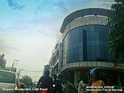
View of Mangaldoi Repose building in LNB Road | |
 Mangaldai  Mangaldai Location in Assam, India | |
| Coordinates: 26°26′N 92°02′E / 26.43°N 92.03°ECoordinates: 26°26′N 92°02′E / 26.43°N 92.03°E | |
| Country |
|
| State | Assam |
| District | Darrang |
| Founded by | Government of Assam |
| Government | |
| • Body | Mangaldoi Municipality Board |
| Elevation | 34 m (112 ft) |
| Population (2011) | |
| • Total | 25,989 |
| Languages | |
| • Official | Assamese |
| Time zone | IST (UTC+5:30) |
| PIN | 784125 |
| Vehicle registration | AS-13 * **** |
| Sex ratio | 923:1000 ♂/♀ |
| Website |
darrang |
Mangaldai (Assamese: মঙ্গলদৈ, /ˈmæŋɡəlˌdɔɪ/; also spelt Mangaldoi) is a small town in the Indian state of Assam. It was named after Mangaldahi, who was the daughter of the Rajah of Darrang and was married to Pratap Singha, a ruler of the Ahom kingdom. Mangaldoi serves as the administrative headquarters of Darrang district, and is an important trading centre for agricultural products. The town is divided into 9 wards.
Geography
Mangaldoi is located at 26°26′N 92°02′E / 26.43°N 92.03°E.[1] It has an average elevation of 34 m (112 ft).
Situated at the north bank of Brahmaputra river, the town is 65 km from Guwahati. Its total area is 5 km2.
Town & Villages nearby include Kharupetia (only Town Committee in Darrang District) Upahupara, Dighirpar, Aulachowka, Saikiapara, Lengeripara, Chapai, Menapara, Dhula, Patharughat, Balipota, Sipajhar, Maroi, Duminichowki, Sanowa, Deomornoi, Kalaigaon, Balugaon and Dalgaon, Lengeriajhar, Jonaram Chowka, Dipila, Duni, Bonmajha - Hengalpara etc.
Landmarks
- District Museum
- Khatara Satra
- Bonmajha Hengalpara
- Silor Khuti Burhaguhain, Lord Siva tanple, Aulachouka - Mekengi Road
- burhinagar pukhuri aru lakhimpur pukhuri
- Mahatma Gandhi Park
- Vishnu Mandir (Temple)
- Ratnawali Temple
- Narikoli Lord Shiva Temple
- Raja Hauli
- Jaljali Pukhuri
- Bar Masjid
- Industry areas
- Horlicks Factory
- JENI Rice Mill, Barangabari, Dighirpar (Bordoulguri Deomornoi Road) PIN : 784144
- Britannia Industry
- Mangaldai River
Colleges and schools
| Name | Courses Available |
|---|---|
| Mangaldai College | Offers bachelor's degrees in Arts & Science streams, Diplomas in various computer fields (B.VOC also included recently) |
| College of Teacher Education, Mangaldai, | Offers Bachelor of Education degree (B.ED.) |
| Mangaldai Law College | Bachelor's and master's degrees in law |
| Mangaldai Commerce College | Bachelor's and master's degrees in commerce |
| Mangaldai Govt Higher Secondary | Arts, Science and Vocational junior college |
| Ranjit Sharma Junior Academy | Arts and Science junior college |
| Brilliant Academy | Arts and Commerce junior college |
| Pathorighat Higher Secondary | SEBA, AHSEC Arts and Commerce |
| PD Academy | Arts and Science junior college |
| Darrang Academy | Arts and science junior college |
| Jnan Vikash Academy | Science and Arts junior college |
| Computer Home | Basic Computer Courses, DTP, Tally. |
| Name | Curicullum |
|---|---|
| Mangaldai Don Bosco High School | SEBA |
| Mangaldai Govt Higher Secondary School (Boy's) | SEBA
Mangaldai Town Girls'Higher Secondary School SEBA |
| Mangaldai Nagar Valika | SEBA |
| Shankardev Sishu Niketan | SEBA |
| North East Academy | SEBA |
| Mangaldai Vidyapith | SEBA |
| Mangaldai Town M E | SEBA |
| Mangaldai Bhaba Shankar School | SEBA |
| Kendriya Vidyalaya Mangaldai | CBSE |
| Maharshi Vidya Mandir Mangaldai | CBSE |
| Holy Child Public School | CBSE |
| Sankardev Sishu Niketon | SEBA |
- Play Way Kids School
- Kidzee
- Kids World
- Blooming Lotus
- Dafodils
Hospitals
- Mangaldai Poly Clinic (Santipara, Hospital Road)
- Mangaldai Civil Hospital (Santipara, near Circuit House)
- Debsons Nursing Home (M.G Road, behind Post Office)
Demographics
As of 2011 India census,[2] Mangaldoi had a population of 42,946. Males constitute 52% of the population and females 48%. Mangaldoi has an average literacy rate of 81%, higher than the national average of 59.5%: male literacy is 85%, and female literacy is 76%. In Mangaldoi, 11% of the population is under 6 years of age.
Governance
Mangaldoi is part of Mangaldoi (Lok Sabha constituency).[3]
Mr. Gurujyoti Das of BJP is the present MLA of Mangaldoi.
References
- ↑ Falling Rain Genomics, Inc - Mangaldoi
- ↑ "Census of India 2001: Data from the 2001 Census, including cities, villages and towns (Provisional)". Census Commission of India. Archived from the original on 2004-06-16. Retrieved 2008-11-01.
- ↑ "List of Parliamentary & Assembly Constituencies" (PDF). Assam. Election Commission of India. Retrieved 2008-10-06.
