Macmillan Bible Atlas
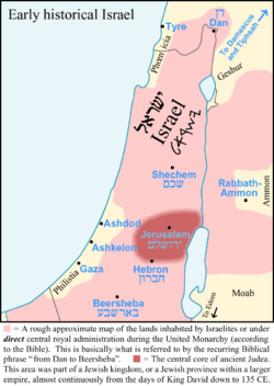
Map image partially influenced by the Macmillan Bible Atlas
The Macmillan Bible Atlas is a book on the geography, civilizations and cartography of the Holy Land. It describes the movements of biblical characters, trade routes and battles. It also refers to archaeological excavations; illustrations of artifacts; and a comparative chronology of early civilizations that relate to the Bible.[1]
When it was first published in 1968, the Library Journal called it "one of the year's most outstanding reference books". The third edition was published in 1993, after which a fourth (2002) and fifth (2011) edition appeared under a new title, Carta Bible Atlas.
See also
References
- Yohanan Aharoni et al., 1968, The Macmillan Bible Atlas, Macmillan Publishers ISBN 0-02-500605-3
This article is issued from Wikipedia - version of the 12/17/2013. The text is available under the Creative Commons Attribution/Share Alike but additional terms may apply for the media files.