MacIntyre Mountains
| MacIntyre Mountains | |
|---|---|
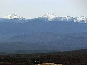
 The MacIntyre Range from St. Regis Mountain. At left is Mount Marcy, with Wright Peak just below it. In the center is Algonquin Peak; Iroquois Peak is at far right. | |
| Highest point | |
| Peak | Algonquin Peak |
| Elevation | 5,115 ft (1,559 m) |
| Coordinates | 44°8′37″N 073°59′12″W / 44.14361°N 73.98667°W |
| Dimensions | |
| Length | 8 mi (13 km) NE–SW |
| Geography | |
| Country | United States |
| State | New York |
| Region | Adirondack Park |
| Range coordinates | 44°08′N 74°00′W / 44.13°N 74°WCoordinates: 44°08′N 74°00′W / 44.13°N 74°W |
The MacIntyre Mountains or MacIntyre Range is a range of mountains in the High Peaks region of the Adirondacks, due west of Mount Marcy, in northeastern New York State. The range runs 8 miles (13 km) from southwest to northeast. Its sheer southwest slope makes up one side of Indian Pass, and a northeastern spur forms the cliffs of Avalanche Pass.
The range includes Iroquois, Mount Marshall, Wright, and Algonquin, the second highest peak in the state. Despite being spelled differently, it is named for the founder of the McIntyre Iron Works at Tahawus, New York, Archibald McIntyre.[1]

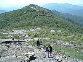
Iroquois Peak seen from Algonquin Peak
See also
References
- ↑ Goodwin, Tony, ed., Adirondack Trails, High Peaks Region, Lake George, New York: Adirondack Mountain Club, 2004. ISBN 1-931951-05-5
- U.S. Geological Survey Geographic Names Information System: MacIntyre Mountains
- "Dix Range". Peakbagger.com. 2004-11-01. Retrieved 2008-04-23.
- "MacIntyre Range". Summitpost.org. 2006-09-05. Retrieved 2008-04-23.
This article is issued from Wikipedia - version of the 9/3/2016. The text is available under the Creative Commons Attribution/Share Alike but additional terms may apply for the media files.