MV Tatsuta Maru
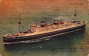
 Tatsuta Maru, c. 1931 | |
| History | |
|---|---|
| Name: | MS Tatsuta Maru |
| Operator: |
|
| Builder: | Mitsubishi Shipbuilding & Engineering Co. Nagasaki, Japan |
| Yard number: | 451 |
| Laid down: | 3 December 1927 |
| Launched: | 12 April 1929 |
| Completed: | 15 March 1930 |
| In service: | 1943 |
| Out of service: | 9 February 1943 |
| Renamed: | 1938, Tatuta Maru |
| Fate: | lost in war |
| Status: | torpedoed and sunk by submarine |
| General characteristics | |
| Tonnage: | 16,975 gross register tons (GRT) |
| Length: | 583 ft (178 m) |
| Beam: | 71 ft (22 m) |
| Propulsion: | 4 Sulzer diesels, quadruple screws |
| Speed: | 21 knots |
| Notes: | Steel construction |
Tatsuta Maru (龍田丸 Tatsuta maru), also known as Tatuta Maru after 1938, was a Japanese ocean liner owned by Nippon Yusen Kaisha. The ship was built in 1927-1930 by Mitsubishi Shipbuilding & Engineering Co. at Nagasaki, Japan.
Tatsuta Maru was built for the trans-Pacific Orient-California fortnightly service.[1] Principal ports-of-call included Hong Kong, Shanghai, Kobe, Yokohama, Honolulu, Los Angeles & San Francisco.[2]
The vessel was created as a twin of Asama Maru; and both ships were named after important Shinto shrines.[3]
History
The shipyard number of the first passenger liner built by NYK was 450 (Asama Maru)[4] and 451 was the yard number of her sister ship, Tatsuta Maru.[5]


Both vessels were built by Mitsubishi at Nagasaki on the southern island of Kyushu. Tatsuta Maru was launched on April 12, 1929. When almost complete, she was severely damaged by fire on 7 February 1930,[6] but the damage was repaired quickly and she soon was completed. She undertook her maiden voyage on March 15, 1930,[5] sailing from Yokohama to San Francisco.[2]
The 16,975-ton vessel had a length of 583 feet (178 m), and her beam was 71 feet (22 m). The ship had four diesel motors, quadruple screws and a service speed of 21-knots.[5] Asama Maru was the second Japanese passenger liner to be propelled by diesel engines.[2]
Pacific War

In December 1941 the liner was part of an elaborate Japanese deception plan to mask the unannounced attack on the US Pacific Fleet in Pearl Harbor. She sailed from Yokohama on 2 December bound for San Francisco with the task of exchanging American evacuees from East Asia for Japanese nationals in the United States. She was scheduled to reach the US on 14 December and despite rumours of war the American press wrongly concluded that meant nothing was likely to happen for some time.
The master of the ship had sealed orders to turn around at midnight on 7 December and return to Japan while maintaining radio silence. Subsequently, Tatsuta Maru was requisitioned as a troopship for the Imperial Japanese Navy.[2]
On February 8, 1943, Tatsuta Maru was torpedoed and sunk by the American submarine Tarpon[5] 42 miles east of Mikurajima.[2]
Some 1,400 Japanese soldiers on board were killed.
See also
Notes
- ↑ Levine, David. Graphic Design from the 1920s and 1930s in Travel Ephemera: "Plan of Passenger Accommodation Motor Ships 'Asama Maru' & ' Tatsuta Maru,'" 1929.
- 1 2 3 4 5 Derby, Sulzer diesel motors: Asama Maru. August 29, 2008.
- ↑ Ponsonby-Fane, Richard. (1935). The Nomenclature of the N.Y.K. Fleet, p. 50.
- ↑ Tate, E. Mowbray. (1986). Transpacific steam: the story of steam navigation from the Pacific Coast of North America to the Far East and the Antipodes, 1867-1941, p. 68
- 1 2 3 4 Haworth, R.B. Miramar Ship Index: Tatsuta Maru, ID#4035362.
- ↑ "Casualty reports". The Times (45432). London. 8 February 1930. col C, p. 21.
References
- Ponsonby-Fane, Richard Arthur Brabazon. (1935). The Nomenclature of the N.Y.K. Fleet. Tokyo : Nippon Yusen Kaisha. OCLC 27933596
- Tate, E. Mowbray. (1986). Transpacific steam: the story of steam navigation from the Pacific Coast of North America to the Far East and the Antipodes, 1867-1941. New York: Cornwall Books. ISBN 978-0-8453-4792-8; OCLC 12370774
- A.J. Barker (1971) Pearl Harbor: Purnell's History of the Second World War Book 10
External links
- DerbySulzer: Tatsuta Maru
Coordinates: 34°00′N 140°00′E / 34.000°N 140.000°E