New Carissa
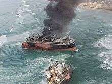
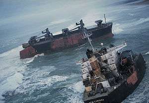 The broken MV New Carissa | |
| History | |
|---|---|
| Name: | New Carissa |
| Owner: | Green Atlas Shipping |
| Operator: | Taiheiyo Kaiun Co. Ltd. |
| Builder: |
Imabari Shipbuilding Co., |
| Laid down: | August 30, 1989 |
| Homeport: |
Manila, |
| Fate: | Ran aground near Coos Bay, Oregon on February 4, 1999; broke apart on beach. Bow towed out to sea, sunk. Stern section remained ashore until being dismantled and removed in 2008. |
| Notes: |
|
| General characteristics | |
| Tonnage: | |
| Length: | 195 m (640 ft) |
| Beam: | 32.2 m (106 ft) |
| Draft: | 10.8 m (35 ft) full load |
| Propulsion: |
|
| Capacity: | Dry Bulk Freight |
| Complement: | 26 crew |
Coordinates: 43°23.92′N 124°18.71′W / 43.39867°N 124.31183°W
MV New Carissa was a freighter that ran aground on a beach near Coos Bay, Oregon, United States, during a storm in February 1999 and subsequently broke apart. An attempt to tow the bow section of the ship out to sea failed when the tow line broke, and the bow was grounded again. Eventually, the bow was successfully towed out to sea and sunk. The stern section remained on the beach near Coos Bay. Fuel on board the ship was burned off in situ, but a significant amount was also spilled from the wreckage, causing ecological damage to the coastline.
The United States Coast Guard performed an investigation and found that captain's error was the main cause of the wreck; however, no criminal liability was established and the captain and crew were not charged. There were significant legal and financial consequences for the ship's owners and insurer.
The stern section remained aground for over nine years. It was dismantled and removed from the beach in 2008.
Vessel
New Carissa was a Panamanian-flagged dry bulk freighter optimized for carriage of woodchips. She was owned by the Japanese shipping concern Nippon Yusen Kaisha via a subsidiary, Green Atlas Shipping. The ship's operator and manager, Taiheiyo Kaiun Co. Ltd. and TMM Co. Ltd. respectively, were also based in Japan.[1] The vessel was built by Imabari Shipbuilding Co. in Japan using an all-steel construction, and was laid down on August 30, 1989. The freighter was 195 meters (639 ft) long and 32 meters (106 ft) wide, with a draft of 10.8 m (35.5 ft) when fully loaded. She had a gross tonnage of 36,571 tons, a net tonnage of 16,524 tons, and was powered by an 8,200 bhp (6,100 kW) direct-drive diesel engine. She had a maximum crew complement of 26 sailors, and was in service hauling woodchips (used for paper pulp production). The ship's home port was Manila, Philippines, and her crew at the time of her grounding consisted entirely of Philippine nationals, commanded by Benjamin Morgado. New Carissa's protection and indemnity insurance was provided by The Britannia Steam Ship Insurance Association Ltd.[2][3] The ship's Certificate of Financial Responsibility, which is required by the Oil Pollution Act of 1990 and included USD $23 million of environmental liability insurance, was provided by Shipowners Insurance and Guaranty Company Ltd. (SIGCo) of Hamilton, Bermuda.[4]
Grounding
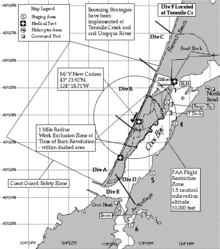
On 4 February 1999, New Carissa was bound for the Port of Coos Bay to pick up a load of wood chips. The ship's crew was informed by the local bar pilots that weather conditions would prevent the ship (which was empty at the time) from entering Coos Bay harbor until the next morning. The captain ordered the ship to drop anchor 1.7 nautical miles (3.1 km) off the coast in order to ride out the storm. The crew used a single anchor to secure the ship. According to a United States Coast Guard review of the incident, the chain used was too short. The short chain and the weather conditions, including winds of 20–25 knots (37–46 km/h), caused the ship to drag her anchor. Poor navigational techniques and inadequate watchkeeping led to the crew's failure to notice that the ship was moving. Once movement was detected, the crew attempted to raise anchor and maneuver away from the shore, but the weather and sea conditions made this difficult. By the time the anchor was raised, the ship had been pushed too close to the shore to recover.[4]
The ship ran aground on the beach 2.7 statute miles (4.5 km) north of the entrance to Coos Bay, and attempts to refloat her failed. Two of the five fuel tanks on the ship began to leak fuel onto the beach, eventually spilling approximately 70,000 US gallons (260 m3) of viscous "bunker C" fuel oil and diesel onto the beach and into the water.[5][6]
Neither the captain nor any of the 22-man crew was injured in the incident.
Rescue and recovery operations
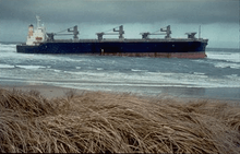
Recovery operations began immediately when the grounding was first reported by the ship's crew. Several factors combined to severely complicate the operation. A Unified Command for the operation, consisting of representatives from the Coast Guard, the State of Oregon, and rescue party operations, was quickly established.
Initial rescue attempts
Initial rescue operations were hampered by inclement weather. Attempts to move New Carissa under her own power failed, and tugboat assistance was not available immediately after the grounding. Only one tugboat was available locally, but she was unable to cross the Coos Bay bar because of safety concerns. It was also uncertain whether or not the locally available tugboat could have successfully rescued New Carissa. The nearest salvage tugboat capable of towing a large ship off a beach, Salvage Chief, was moored at her home port of Astoria, Oregon, 200 statute miles (320 km) to the north, a 24-hour journey away. Salvage Chief had not sailed in over a year, and it took 18 hours to fuel, provision, and find a crew for the ship. Once mobilized, poor weather in the Astoria area prevented the tugboat from crossing the treacherous Columbia River bar for an additional two days. Salvage Chief did not arrive in the area until 8 February four days after the grounding occurred.[7]
Continued poor weather drove New Carissa closer to the shore. Technical teams from two salvage contractors, Smit International and Salvage Master, had been working with the Coast Guard since February 5 and had drawn up plans to attempt to refloat the vessel, but when cracks in the hull and oil leaks were observed on February 8, any refloating attempts were precluded by the focus on preventing of a large-scale oil spill.[8] In addition, Salvage Chief, upon her arrival, was unable to reach New Carissa with her tow gear. On 10 February New Carissa suffered major structural failure when the hull breached near the engine room, flooding the engines with seawater (and thus disabling them). The ship's insurers declared the vessel to be a total loss. As a result, New Carissa was no longer a salvageable vessel; instead, she had effectively become a shipwreck.[7]
Wreck recovery operations
Since the vessel was no longer seaworthy and could not move under its own power, even if freed from the beach, the focus of the operation changed. Oil from the ship's fuel tanks continued to pose an environmental hazard, a situation exacerbated by both the ship's structural failure and continuing pounding from the surf. In order to mitigate the situation, the Unified Command decided to set the fuel tanks on fire in order to burn off the oil. The first attempt was made on February 10. Napalm and other incendiary devices were used to ignite the fuel, but only one of the diesel tanks was burned effectively. A second attempt was made on February 11 when US Navy explosive experts placed 39 shaped charges to breach the top of the fuel tanks from within the cargo holds. 2,280 liters of napalm and nearly 180 kg of plastic explosives were also used to ignite the fuel on board. The ship burned for approximately 33 hours.[8] Additional smaller-scale attempts were made to burn more oil over the next two days, with limited success. The total amount of oil that was burned is estimated to be between 165,000 and 255,000 US gallons (620 and 970 m3).[8] The structural stress caused by the fire, combined with continued severe weather, caused the vessel to break into two sections around midnight on February 11.
After additional weather-related delays, on February 26 salvors managed to float the 440–foot (132 m) bow section and began the process of towing it out to sea for disposal. By March 1, the tugboat Sea Victory had towed the bow from the beach and out to sea, initially followed by an oil skimmer vessel, OSRV Oregon Responder.[9] However, another severe storm forced the skimmer back to port, and when the tug was 50 miles (65 km) off the coast, the tow line broke.[9] The bow section floated for fourteen hours until it ran aground near Waldport, Oregon on March 3, approximately 80 miles (130 km) to the north of the original grounding site. On March 8, the bow was again refloated, and by March 11 it was successfully towed 280 miles (450 km) off the coast by Sea Victory and a second tug, Natoma.[9] At this location, the Pacific Ocean is approximately 10,000 feet (3,000 m) deep. The bow was sunk by two US Navy ships, the destroyer USS David R. Ray and the submarine USS Bremerton. Four hundred pounds (180 kg) of high explosives were attached to the bow and detonated.[9] Sixty-nine rounds of gunfire from David R. Ray's 5-inch (127 mm) deck guns then punctured the hull. After 40 minutes, the ship was still afloat with darkness and a storm approaching. To expedite the sinking, Bremerton fired a Mark 48 torpedo at the underside of the ship. Within ten minutes, the bow section flooded and sank stern-first, trapping the remaining oil within.[10]
The stern section remained aground, but did not pose a significant oil spill threat as the majority of the oil on board had already leaked or burned. Some remaining oil that was found on board was skimmed or pumped out manually.[9] In June 1999, Green Atlas awarded a ship breaking contract to Donjon Marine Co. and Fred Devine Diving and Salvage.[9] Although the two companies were able to remove approximately one-third of the stern, their attempts to dismantle the largest section or tow it to sea were unsuccessful and had to be abandoned over the winter.[1][3] However, work did not resume in the spring of 2000, and in 2001, a salvage expert hired by Green Atlas claimed the stern should not be removed because it would create a dangerous work environment.[11] The state later accused Green Atlas of sabotaging the stern removal effort in order to save money; a protracted legal battle ensued.[12]
Dismantling and removal of stern section
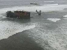
Although the initial attempts to dismantle or tow the stern to sea failed, the State of Oregon still intended to see the remainder of the vessel removed from the beach. In 2006, the state's lawsuit against the ship's owners was settled, clearing the legal obstacles that prevented removal and providing the funds necessary to finance the project. Removal plans were complicated by the fact that the stern had become deeply embedded in the sand in the seven years since the wreck, with some portions of the stern estimated to be 20–30 feet (6–9 m) below the sand line.[13]
A project to remove the stern by dismantling it on the beach was started in June 2008, after Oregon legislative approval.[14] The dismantling, expected to cost USD $18 million, was approved by the State Legislative Emergency Board in September 2006.[15] The move was originally scheduled for 2007, but delays in the negotiations pushed the project back a year. Due to weather and surf conditions, the project had to be undertaken during the spring and summer months.[15] Titan Maritime Company, a subsidiary of Crowley Maritime Corporation, signed a USD $16.4 million contract with the Oregon Department of State Lands.[11][16] Titan Maritime used large jackup barges, Karlissa A and Karlissa B, for the New Carissa dismantling project. Once the barges were in place, a cable car system was installed to allow the crews and their equipment access to the barges from the beach.[14] The barges allowed the crews to access the wreck from 40 ft (12.2 m) above the surf.[14] The crews cut New Carissa into removable pieces and then lifted them to the barges with cranes.[13] The cutting portion of Titan's plan was largely completed by July 31, 2008, and the company then focused on pulling the stern from the sand, a process that was measured in inches.[17][18] The project's managing director expressed confidence that the removal deadline of October 1, 2008 would be met.[14][19] By September 2008, Titan had successfully removed the majority of the wreck; no part of the ship was visible from above the water, and only a few relatively small pieces remained submerged.[20] Karlissa A and Karlissa B were relocated on October 12, 2008, and Titan's shore operations were completely removed by November 2008.[21]

Debate about removal
Prior to the dismantling project, there was debate by local residents on whether the wrecked stern should be removed. Some local officials believed the stern, which lay on a remote area of the beach, was not a hazard or an eyesore. Arnie Roblan, a state representative from Coos Bay, called the wreck a potential tourist attraction.[22] For some residents, uncertainty remained surrounding Titan's removal plan, with the worry that the stern would be unable to withstand the force of the hydraulic pullers and that parts of the ship already buried in the sand would be unmovable. The president of the Coos Bay city council expressed concern that the proposed removal operation could cause ecological damage that would not occur if the ship were left on the beach. He further noted that "shipwrecks on the Oregon Coast are part of our history. There are a lot of ways you could better spend the money here."[13]
Many others argued that the ship should be removed. Louise Solliday, the director of the Oregon Department of State Lands, called the removal of the stern a necessary step to demonstrate that the state is "serious about removing wrecks". She stated that if the stern were not removed, the argument that the ship is trespassing on state property (used in the state's lawsuit against New Carissa owners) would be undermined should another vessel wreck off the Oregon coast.[23] The sentiment was later echoed by Oregon Secretary of State Bill Bradbury, who also noted that the settlement of the lawsuit with the ship's owners leaves the state exposed to any liability issues concerning the ship.[13] Many environmentalists, as well as federal biologists and residents of the local community, were concerned about the potential for further ecological damage should the vessel leak any of the fuel oil that remained on board.[11] The editorial board of The Oregonian argued that allowing the stern to remain would send a message that the state is willing to "tolerate permanent damage to its beaches". The newspaper also rejected the notion that the wreckage should be compared to the Peter Iredale, a sailing ship that wrecked on a beach near Astoria in the early 1900s, and whose remnants are a popular tourist draw.[24]
Environmental impact
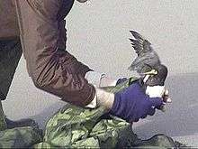
The wreck of New Carissa caused one of the most serious oil spills to affect the state of Oregon, and the worst since a 1984 spill near Longview, Washington that dumped 200,000 US gallons (760 m3) of oil into the Columbia River.[25] As Oregon has no significant oil refinery facilities, oil tankers do not often dock at its ports, making the state relatively safe from oil spills.[26] Analysis conducted by the U.S. Fish and Wildlife Service determined that over 3,000 shorebirds and seabirds perished. The birds belonged to more than 50 species.[27][28] Among the birds killed were 262 threatened marbled murrelets and between four and eight endangered western snowy plovers.[29] Harbor seals, fish, and shellfish were also killed or affected. Several beaches were fouled, with tarballs continuing to wash up for more than a month after the wreck.[30]
Despite the loss of marine life, the initial burning of the oil and the successful removal of the bow section prevented what could have been a worse spill. Captain Mike Hall of the Coast Guard stated that "at least 82 percent of the oil on board New Carissa never reached the wildlife or the pristine shoreline of Oregon's coast".[30] The environmental impact of the sinking of the bow section was thought to be minimized since it was towed out beyond the continental shelf, into very deep water. Any remaining oil on board is unlikely to have affected marine life since the low temperatures at the bottom of the ocean would have caused it to solidify.[31]
Prior to the stern section's removal from the beach, environmentalists and local officials were concerned that the remains posed a continuing environmental and safety hazard.[11]
Legal aftermath
Subsequent litigation proved expensive for the ship's owners and insurers, and an investigation into the incident delayed most of the crew's return to their home country.
Litigation
In 2001, Green Atlas Shipping and its insurer, Britannia Steam Ship Insurance Association, sued the United States for US$96 million, claiming negligence on the part of the Coast Guard due to faulty nautical charts.[11] They also alleged failure on the part of the local bar pilots to advise the ship's crew not to anchor in the area, and that dredging by the United States Army Corps of Engineers had exacerbated the problems with the anchor.[2] The U.S. countersued for US$7 million in damages. In 2004, the two sides reached an agreement in which Green Atlas would pay the U.S. US$10.5 million to assist with cleanup costs, and the U.S. paid Green Atlas US$4 million in settlement of the faulty charts claim. The net result of the settlement was payment of US$6.5 million to the U.S.[32] Although this was far less than the damages claimed by the U.S. for environmental cleanup and restoration costs, government officials still saw the settlement as a victory since the shipping company was forced to pay for part of the damage. Some Coos County officials were dissatisfied with the settlement, however, stating that it should have instead been paid to local business owners who were negatively impacted by the closure of the beach.[33]
The State of Oregon demanded that the ship's owners or their insurers remove the ship or pay a US$25 million bond to cover the cost of removing the ship and for environmental damages. The state also filed a lawsuit in Coos County, demanding removal, storage fees of USD $1,500 per day, restoration of the beach, and other unspecified damages. The state alleged negligence on the part of Morgado and also accused Green Atlas shipping of attempting to avoid the expense of the stern dismantling.[34] On November 13, 2002, a Coos County jury found the ship's owners guilty of negligent trespass, and awarded the state US$25 million in damages. That sum was placed in escrow, pending appeal.[11] On May 23, 2006, a settlement was reached in the appeal; the state kept US$20 million of the US$25 million in escrow, plus US$2.1 million in interest earned on the escrow account. The remaining US$5 million was returned to Green Atlas Shipping. Of the US$22.1 million that the state was awarded in the settlement, US$3.1 million was used to pay the state's legal fees. The remaining US$19 million was reserved for cleanup, including the removal of the vessel's stern.[23][35]
Numerous private parties, including at least one oyster farmer whose beds were contaminated by oil, successfully sued for damages.[36]
Crew investigation
The captain and most of the crew of the ship—all nationals of the Philippines—had to face a U.S. Coast Guard Board of Inquiry, which required them to remain in the United States for several weeks after the wreck. In addition, a federal grand jury investigated the incident for criminal wrongdoing. Captain Morgado refused to answer many of the questions posed at the inquiry, citing his Fifth Amendment rights. The crew was released after their testimony and returned to the Philippines.[37] On September 16, the Coast Guard issued its findings that captain's error was the primary cause of the wreck, with the first and third officers of the ship also partly responsible. The investigation found no evidence of criminal wrongdoing, and no charges were filed against any member of the New Carissa crew.[38]
In popular culture
Portland-based musician Sarah Dougher's 2000 album The Walls Ablaze included a song titled "The New Carissa".[39]
Notes
- 1 2 "New Carissa Fact Sheet" (PDF). Oregon Department of State Lands. March 2009. Retrieved 25 February 2016.
- 1 2 Bacon, Larry (2001-02-03). "Carissa parties file lawsuit". Eugene Register-Guard. p. 1A.
- 1 2 "Crews abandon effort to move New Carissa's stern from beach". The Associated Press. 1999-12-02.
- 1 2 Hall, Captain Michael J. (June 1999). "Crisis on the Coast" (PDF). U.S. Coast Guard. Retrieved 2012-05-17.
- ↑ "Environmental Global Issues Map: New Carissa Oil Spill on the Oregon Coast". McGraw-Hill. March 1999. Retrieved 2006-06-13.
- ↑ It is impossible to determine the exact amounts of fuel oil and diesel that were spilled. The figure most commonly quoted by both media and government sources is 70,000 US gallons (260 m3). The US Fish and Wildlife Service has noted that some estimates ranged from 25,000 to 140,000 US gallons (95 to 530 m3).
- 1 2 Review Committee; M. Lehman-Chair; et al. (April 2000). "New Carissa: Report and Recommendations to the Governor of the State of Oregon" (PDF). Oregon Department of Environmental Quality. Retrieved 2006-06-13.
- 1 2 3 Michel, Jacqueline. "Interim Preassessment Report, M/V New Carissa Oil Spill, Coos Bay and Waldport, Oregon" (PDF). US Fish and Wildlife Service. Retrieved 2006-11-21.
- 1 2 3 4 5 6 Hall, Michael; Wyland, Jacqueline. "Crisis on the Coast: The Grounding of the M/V New Carissa" (PDF). Proceedings Magazine. Coast Guard's Marine Safety and Environmental Protection Directorate. p. 20. Retrieved 17 May 2012.
- ↑ "Bow of New Carissa Sinks to Resting Site" (Press release). New Carissa joint information center. 1999-03-11. Retrieved 2006-06-13.
- 1 2 3 4 5 6 "The Wreck of the New Carissa". Land and Waterway Management. Oregon Department of State Lands. Retrieved 2006-06-13.
- ↑ "$50 million in damages sought over grounding of New Carissa". The Associated Press. 2002-08-28. Retrieved 17 May 2012.
- 1 2 3 4 "State Determined to Remove New Carissa". Associated Press. 2006-08-15. Retrieved 2006-06-15.
- 1 2 3 4 Guzman, Jolene (2008-06-03). "Titan moves barge into place next to New Carissa". The World (Coos Bay, Oregon). Retrieved 2006-07-31.
- 1 2 Carl Mickelson (2007-01-10). "New Carissa will remain beached for another year". The World (Coos Bay, Oregon).
- ↑ "The New Carissa - Q & A" (pdf). Oregon Department of State Lands. 2008-07-29. Retrieved 2010-07-12.
- ↑ Guzman, Jolene (2008-07-31). "It's come full circle". The World (Coos Bay, Oregon). Retrieved 2006-07-31.
- ↑ "Waves help shift the New Carissa". The World (Coos Bay, Oregon). 2008-07-31. Retrieved 2006-07-31.
- ↑ Guzman, Jolene (2008-07-29). "General Chaos". The World (Coos Bay, Oregon). Retrieved 2006-07-31.
- ↑ Banse, Tom (2008-08-25). "New Carissa Going... Going... Not Quite Gone". OPB News. Retrieved 2008-08-26.
- ↑ "The Wreck of the New Carissa: Information Updates". Oregon Department of State Lands. Retrieved 2010-07-12.
- ↑ McCall, William (2006-05-23). "Land board settles New Carissa shipwreck cleanup for $22 million". Associated Press. Retrieved 2007-03-30.
- 1 2 O'Neill, Patrick (2006-05-24). "Channel cleared for New Carissa's last trip". The Oregonian. Retrieved 2006-06-13.
- ↑ "Beach cleanup: The New Carissa must go". The Oregonian. 2006-05-28. Retrieved 2006-08-16.
- ↑ "Oil spills and near-misses in Northwest waters". Seattle Post-Intelligencer. 2002-11-21.
- ↑ "U.S. Directory of Operable Petroleum Refineries" (PDF). Energy Information Administration. 2004.
- ↑ "The New Carissa Damage Assessment Restoration Plan "Q&A"." (PDF). US Fish and Wildlife Service. Archived from the original (PDF) on June 25, 2006. Retrieved 2006-06-13.
- ↑ Merems, Arlene (1999-09-15). "Morgue species count update (memorandum)" (PDF). Oregon Department of Fish and Wildlife. Retrieved 2006-06-13.
- ↑ Skrabis, Kristin E. (2006-05-02). "Resource Equivalency Analysis for Western Snowy Plover" (PDF). US Department of the Interior. Retrieved 2006-06-10.
- 1 2 "Oil Skimmer Oregon Responder Does Not Find Oil After Bow of New Carissa Sinks" (Press release). New Carissa joint information center. 1999-03-12. Retrieved 2006-06-13.
- ↑ "New Carissa Midway to Final Resting Place" (Press release). New Carissa joint information center. 1999-03-09. Retrieved 2006-06-13.
- ↑ "The Wreck of the New Carissa timeline". Land and Waterway Management. Oregon Department of State Lands. Retrieved 2006-08-16.
- ↑ "U.S. agrees on New Carissa settlement". Associated Press. 2004-06-10. Archived from the original on June 20, 2004. Retrieved 2014-08-21.
- ↑ Bishop, Bill (2002-11-13). "State claims Carissa's anchoring flawed". Eugene Register-Guard. p. 1D, 5D. Retrieved 17 May 2012.
- ↑ "State Land Board approves settlement to remove wreckage of New Carissa" (Press release). Oregon Department of State Lands. 2006-05-23. Retrieved 2006-08-16.
- ↑ "A 1999 Cargo Disaster (A Maritime Saga): The Loss Of M/V New Carissa". The Cargo Letter. October 2001. Retrieved 2006-06-13.
- ↑ Rumler, John (1999-03-11). "The Sailors Behind the Shipwreck". AsianWeek. Retrieved 2006-06-13.
- ↑ Lockwood, Commander Christopher K. (1999-09-16). Investigation Into the Circumstances Surrounding the Grounding of the Motor Vessel NEW CARISSA, Lloyd's Number L8716136, off Coos Bay, Oregon, on 04 February 1999, with Major Pollution and No Personal Injuries or Loss of Life (Report). Investigation Report to Commandant, US Coast Guard [G-MOA]. U.S. Coast Guard.
- ↑ Wilson, Mackenzie. "The Walls Ablaze review". Allmusic.com. Retrieved 3 August 2011.
References
- Newport Internet New Carissa coverage, with original press releases
- Official NOAA website
- Oregon Department of Environmental Quality: New Carissa Review Committee
- OregonLive.com coverage
- Oregon Fish & Wildlife Department, Key Information on the New Carissa Oil Spill Final Restoration Plan
- Oregon Department of State Lands coverage of the site
External links
| Wikimedia Commons has media related to New Carissa (ship, 1989). |
- Spinreel.com: The Shipwreck of the New Carissa
- Greif, Steve. "New Carissa". The Oregon Encyclopedia.
- Ship Structure Committee: Case Study I: New Carissa, hull failure analysis
- Satellite image from Google Maps
