List of listed buildings in Kiltarlity and Convinth
This is a list of listed buildings in the parish of Kiltarlity and Convinth in the Highland council area of Scotland. This includes the villages of Kiltarlity, Struy and Tomich, as well as the surrounding areas of Glen Convinth and Strathglass.
List
| Name | Location | Date Listed | Grid Ref. [note 1] | Geo-coordinates | Notes | HB Number [note 2] | Image |
|---|---|---|---|---|---|---|---|
| Tomich Hotel, Post Office and Former Stables | Tomich | 57°18′19″N 4°48′42″W / 57.305411°N 4.811769°W | Category C(S) | 8120 | 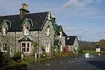
| ||
| East Lodge and Gate Piers, Beaufort Castle | Beaufort | 57°27′24″N 4°27′58″W / 57.4567°N 4.466009°W | Category B | 8069 | 
| ||
| West Lodge, Beaufort Castle | Beaufort | 57°26′43″N 4°30′26″W / 57.445204°N 4.507119°W | Category C(S) | 8070 |
| ||
| Beaufort Cottage Gardener's Cottage | Beaufort | 57°26′52″N 4°29′50″W / 57.447846°N 4.497182°W | Category B | 8071 |
| ||
| Belladrum Temple | Belladrum | 57°26′26″N 4°27′59″W / 57.44066°N 4.466462°W | Category B | 8075 | 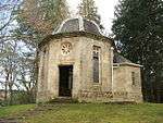
| ||
| Lovat Bridge Over River Beauly | River Beauly | 57°28′14″N 4°28′33″W / 57.470588°N 4.475851°W | Category A | 8083 | |||
| 1,2,3,4,5,6, Belladrum Farm Cottages | Belladrum | 57°26′20″N 4°27′58″W / 57.438753°N 4.4661°W | Category B | 8096 |
| ||
| St Mary's Roman Catholic Church and Burial Ground | Eskadale | 57°25′24″N 4°34′34″W / 57.423223°N 4.576192°W | Category B | 8105 |
| ||
| Achanagleish Cottage, Guisachan | By Tomich | 57°17′17″N 4°50′15″W / 57.2881°N 4.837419°W | Category C(S) | 8106 |
| ||
| Guisachan Cottage | Tomich | 57°18′04″N 4°49′12″W / 57.301111°N 4.819991°W | Category B | 8111 |
| ||
| 1, 2, 3, Tomich "Ardastur" | Tomich | 57°18′13″N 4°48′54″W / 57.303542°N 4.81498°W | Category C(S) | 8113 |
| ||
| 8, 9 Tomich | Tomich | 57°18′15″N 4°48′49″W / 57.304291°N 4.813659°W | Category B | 8116 |
| ||
| Entrance to Guisachan Farm with Gate Piers and Gates | Tomich | 57°18′17″N 4°48′45″W / 57.304611°N 4.812588°W | Category C(S) | 8122 |
| ||
| Beaufort Castle | Beaufort | 57°27′10″N 4°29′25″W / 57.452708°N 4.490345°W | Category A | 8068 | .jpg)
| ||
| Beaufort Castle Walled Garden | Beaufort | 57°26′48″N 4°29′46″W / 57.446773°N 4.495992°W | Category B | 8072 |
| ||
| Former Stables And Steading Range, Phoineas | Belladrum | 57°27′15″N 4°27′34″W / 57.454212°N 4.459539°W | Category C(S) | 8085 |
| ||
| 16, 17, 18, Tomich | Tomich | 57°18′20″N 4°48′37″W / 57.305434°N 4.810359°W | Category C(S) | 8087 |
| ||
| Pair Cottages to Rear of Steading Square, Guisachan Farm, By Tomich | Tomich | 57°18′07″N 4°48′47″W / 57.301868°N 4.813092°W | Category C(S) | 8092 |
| ||
| Walled Garden and Gardener's Cottage, Belladrum | Belladrum | 57°26′24″N 4°27′58″W / 57.440076°N 4.465989°W | Category B | 8094 |
| ||
| Belladrum Lodge | Belladrum | 57°27′01″N 4°28′04″W / 57.450179°N 4.467686°W | Category B | 8098 |
| ||
| 12, 13 Tomich | Tomich | 57°18′18″N 4°48′46″W / 57.304878°N 4.812708°W | Category C(S) | 8118 |
| ||
| 22, 23, 24, Tomich | Tomich | 57°18′23″N 4°48′29″W / 57.306339°N 4.808054°W | Category C(S) | 8089 |
| ||
| Erchless Castle | By Struy | 57°25′47″N 4°38′58″W / 57.429704°N 4.649322°W | Category B | 8100 | .jpg)
| ||
| Knockfin Bridge Over River Deabhag | Tomich | 57°18′04″N 4°49′15″W / 57.301099°N 4.82092°W | Category B | 8109 |
| ||
| Tomich, Corrie Lodge (Comprising East Wing, Corrie Lodge and West Wing) | Tomich | 57°18′05″N 4°49′09″W / 57.30149°N 4.819107°W | Category C(S) | 8112 |
| ||
| 6, 7 Tomich | Tomich | 57°18′15″N 4°48′51″W / 57.30413°N 4.814029°W | Category C(S) | 8115 |
| ||
| 10, 11 Tomich | Tomich | 57°18′16″N 4°48′48″W / 57.30456°N 4.813281°W | Category C(S) | 8117 |
| ||
| Beaufort Castle, The Coach House, Including Ancillary Structure | Beaufort | 57°27′15″N 4°29′47″W / 57.454043°N 4.496438°W | Category C(S) | 47970 |
| ||
| 14, Tomich, Gate House | Tomich | 57°18′17″N 4°48′44″W / 57.304735°N 4.812265°W | Category B | 8123 |
| ||
| 15 Tomich | Tomich | 57°18′17″N 4°48′43″W / 57.304829°N 4.812073°W | Category C(S) | 8124 |
| ||
| Free Church Manse | Kiltarlity | 57°25′53″N 4°29′04″W / 57.4315°N 4.484472°W | Category B | 8079 |
| ||
| The Old Manse, (Formerly Rivendell) | Kiltarlity | 57°26′23″N 4°29′16″W / 57.439687°N 4.487644°W | Category B | 8082 |
| ||
| Struy Bridge Over River Farrar | Struy | 57°25′32″N 4°39′48″W / 57.425598°N 4.663352°W | Category B | 8086 |
| ||
| Guisachan Farm Steading | By Tomich | 57°18′04″N 4°48′49″W / 57.301246°N 4.813559°W | Category B | 8091 |
| ||
| 4, 5 Tomich | Tomich | 57°18′14″N 4°48′52″W / 57.30385°N 4.814456°W | Category B | 8114 |
| ||
| Belladrum Gazebo | Belladrum | 57°26′59″N 4°27′38″W / 57.449682°N 4.460519°W | Category B | 8074 |
| ||
| Chapel House, St Mary's Church | Eskadale | 57°25′25″N 4°34′34″W / 57.423667°N 4.576007°W | Category C(S) | 8077 |
| ||
| Kiltarlity Parish Church Of Scotland and Burial Ground, Tomnacross | Kiltarlity | 57°26′18″N 4°28′46″W / 57.43825°N 4.479381°W | Category B | 8078 |
| ||
| Guisachan Farm House | By Tomich | 57°18′08″N 4°48′48″W / 57.302266°N 4.813372°W | Category C(S) | 8090 |
| ||
| Belladrum Steading | Belladrum | 57°26′21″N 4°28′00″W / 57.439101°N 4.46669°W | Category B | 8095 |
| ||
| Belladrum Farm Henhouse | Belladrum | 57°26′18″N 4°27′59″W / 57.438425°N 4.466361°W | Category C(S) | 8097 |
| ||
| Eskadale House | Eskdale | 57°26′05″N 4°33′23″W / 57.43469°N 4.556337°W | Category B | 8104 |
| ||
| Former Stables, Guisachan | Tomich | 57°16′59″N 4°50′55″W / 57.283155°N 4.848638°W | Category B | 8125 |
| ||
| Beaufort Home Farm Steading | Beaufort | 57°26′42″N 4°30′08″W / 57.444926°N 4.502166°W | Category B | 8073 |
| ||
| Kiltarlity Free Church of Scotland | Kiltarlity | 57°26′10″N 4°29′23″W / 57.435988°N 4.489709°W | Category B | 8080 |
| ||
| Kiltarlity Old Parish Church and Burial Ground | By River Beauly | 57°27′38″N 4°30′23″W / 57.460648°N 4.506392°W | Category B | 8081 |
| ||
| 19, 20, 21, Tomich | Tomich | 57°18′21″N 4°48′33″W / 57.305953°N 4.809253°W | Category C(S) | 8088 |
| ||
| Convinth Burial Ground | Glen Convinth | 57°24′11″N 4°28′41″W / 57.402933°N 4.478109°W | Category C(S) | 8099 |
| ||
| Erchless Castle Walled Garden | By Struy | 57°25′49″N 4°39′06″W / 57.430303°N 4.651598°W | Category B | 8102 |
| ||
| Plodda Cottage, Guisachan | By Tomich | 57°16′46″N 4°51′21″W / 57.279426°N 4.855751°W | Category C(S) | 8107 |
| ||
| East Lodge to Former Guisachan House | Tomich | 57°18′02″N 4°49′07″W / 57.300648°N 4.818578°W | Category B | 8110 |
| ||
| Tweedmouth Memorial Fountain | Tomich | 57°18′14″N 4°48′50″W / 57.303799°N 4.813921°W | Category B | 8121 | 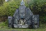
| ||
| Stables at St Mary's Church | Eskadale | 57°25′23″N 4°34′40″W / 57.422984°N 4.577775°W | Category B | 8076 |
| ||
| Guisachan Farm Dairy | By Tomich | 57°18′07″N 4°48′50″W / 57.302065°N 4.813937°W | Category B | 8093 |
| ||
| Erchless Castle Stable/Steading | By Struy | 57°25′51″N 4°39′01″W / 57.430734°N 4.650329°W | Category B | 8101 |
| ||
| Erchless Castle Burial Ground | By Struy | 57°25′56″N 4°38′57″W / 57.432204°N 4.649253°W | Category C(S) | 8103 |
| ||
| Former Erchless Church Of Scotland Manse, Struy | By Struy | 57°25′46″N 4°39′28″W / 57.4295°N 4.657721°W | Category B | 8108 |
| ||
| "Mealbane", Tomich | Tomich | 57°18′18″N 4°48′44″W / 57.305132°N 4.812212°W | Category C(S) | 8119 |
| ||
| Phoineas House | Belladrum | 57°27′06″N 4°27′37″W / 57.451584°N 4.460213°W | Category B | 8084 |
|
Key
The scheme for classifying buildings in Scotland is:
- Category A: "buildings of national or international importance, either architectural or historic, or fine little-altered examples of some particular period, style or building type."[1]
- Category B: "buildings of regional or more than local importance, or major examples of some particular period, style or building type which may have been altered."[1]
- Category C(S): "buildings of local importance, lesser examples of any period, style, or building type, as originally constructed or moderately altered; and simple traditional buildings which group well with others in categories A and B."[1]
There are approximately 47,400 listed buildings in Scotland. Of these, around 8 per cent (some 3,800) are Category A, and 51 per cent (24,000) are Category B, with the rest listed at Category C(s).[2]
See also
Notes
- ↑ Sometimes known as OSGB36, the grid reference (where provided) is based on the British national grid reference system used by the Ordnance Survey.
• "Guide to National Grid". Ordnance Survey. Retrieved 2007-12-12.
• "Get-a-map". Ordnance Survey. Retrieved 2007-12-17. - ↑ The "HB Number" is a unique number assigned to each listed building by Historic Scotland.
References
- All entries, addresses and coordinates are based on data from Historic Scotland. This data falls under the Open Government Licence
- 1 2 3 "What is Listing?". Historic Scotland. Retrieved 2010-07-06.
- ↑ Guide to the Protection of Scotland’s Listed Buildings (PDF). Historic Scotland. 2009. p. 17. ISBN 978-1-84917-013-0. Retrieved 2010-07-06.
This article is issued from Wikipedia - version of the 10/15/2016. The text is available under the Creative Commons Attribution/Share Alike but additional terms may apply for the media files.