Lerhupur
| Lerhupur लेरहूपुर | |
|---|---|
| Census town & village | |
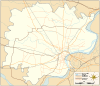 Lerhupur  Lerhupur  Lerhupur Census town & village location on Varanasi district map | |
| Coordinates: 25°21′28″N 83°02′25″E / 25.357836°N 83.040165°ECoordinates: 25°21′28″N 83°02′25″E / 25.357836°N 83.040165°E | |
| Country |
|
| State | Uttar Pradesh |
| District | Varanasi district |
| Tehsil | Varanasi tehsil |
| Elevation | 78 m (256 ft) |
| Population (2011) | |
| • Total | 6,934 [1] |
| Languages | |
| • Official | Hindi & English |
| Time zone | IST (UTC+5:30) |
| Postal code | 221007 [2] |
| Telephone code | +91-542 [3] |
| Vehicle registration | UP65 XXXX |
| Census town & village code | 209748 |
| Lok Sabha constituency | Varanasi (Lok Sabha constituency) [4] |
| Vidhan Sabha constituency | Varanasi Cantt. [4] |
Lerhupur (Hindi: लेरहूपुर) is a census town & village in Varanasi tehsil of Varanasi district in the Indian state of Uttar Pradesh.[1][5] The census town & village falls under the Ladhupur gram panchayat.[5] Lerhupur Census town & village is about 8 kilometers North-West of Varanasi railway station, 305 kilometers South-East of Lucknow and 17 kilometers North-West of Banaras Hindu University.[6][7][8][9]
Demography
Lerhupur has families with a total population of 6,934. Sex ratio of the census town & village is 876 and child sex ratio is 902. Uttar Pradesh state average for both ratios is 912 and 902 respectively [note].[1]
| Details | Male | Female | Total | Comments |
|---|---|---|---|---|
| Number of houses | - | - | 1,057 | (census 2011)[1] |
| Adult | - | - | 5,808 | |
| Children | - | - | 1,126 | |
| Total population | 3,696 | 3,238 | 6,934 | |
| Literacy | 78.9% | 62.2% | 71.1% | |
Transportation
Lerhupur is connected by air (Lal Bahadur Shastri Airport), by train (Varanasi railway station) and by road. Nearest operational airports is Lal Bahadur Shastri Airport and nearest operational railway station is Varanasi railway station (25 and 8 kilometers respectively from Lerhupur).[6]
See also
Notes
- ^ All demographic data is based on 2011 Census of India.
References
- 1 2 3 4 "Demography". 2011 Census of India website. Retrieved Nov 2015. Check date values in:
|access-date=(help) - ↑ "Post code". mapsofindia.com. Retrieved Nov 2015. Check date values in:
|access-date=(help) - ↑ "Dialing code". onefivenine.com. Retrieved Nov 2015. Check date values in:
|access-date=(help) - 1 2 "Delimitation 2008" (PDF). Election Commission of India website. Retrieved Nov 2015. Check date values in:
|access-date=(help) - 1 2 "Census town & village details". Local Government directory. Retrieved Nov 2015. Check date values in:
|access-date=(help) - 1 2 "Distances". Google Maps. Retrieved Nov 2015. Check date values in:
|access-date=(help) - ↑ "Census town & village coordinates". latlong.net. Retrieved Nov 2015. Check date values in:
|access-date=(help) - ↑ "Elevation". daftlogic.com. Retrieved Nov 2015. Check date values in:
|access-date=(help) - ↑ "Census town & village info". WikiEdit.Org. Retrieved Nov 2015. Check date values in:
|access-date=(help)
Villages in Varanasi district | ||
|---|---|---|
| Pindra Tehsil |
| |
| Varanasi Tehsil | ||
India : Uttar Pradesh : Varanasi | ||
 |
Lal Bahadur Shastri Airport (25 km) | Sarnath (3 km) | | |
| Paharia (3.5 km) | |
Chiraigaon (1.5 km) | ||
| ||||
| | ||||
| Bhelupur (11 km) | Vasanta College for Women (6.5 km) |