Laâyoune Province

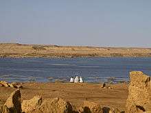
Water reservoir at the Seguiet-el-Hamra River
Laâyoune (Arabic:إقليم العيون) is delineated a province in the north-west of Moroccan economic region of Laâyoune-Sakia El Hamra, which is situated within the northern part of the disputed territory of Western Sahara. Its population in 2004 was 210,023 (when it still included the population of the new Tarfaya Province, created in 2009). In today's limits of the province the population was 199,603.[1] Its main town is El Aaiún (Laâyoune).[2]
Subdivisions
The province is divided administratively into the following:[3]
| Name | Geographic code | Type | Households | Population (2004) | Foreign population | Moroccan population | Notes |
|---|---|---|---|---|---|---|---|
| El Marsa | 321.01.01. | Municipality | 2850 | 10229 | 11 | 10218 | |
| El Aaiún | 321.01.03. | Municipality | 37545 | 183691 | 477 | 183214 | |
| Bou Craa | 321.03.01. | Rural commune | 505 | 2519 | 0 | 2519 | |
| Dcheira | 321.03.03. | Rural commune | 313 | 1745 | 1 | 1744 | |
| Foum El Oued | 321.03.05. | Rural commune | 325 | 1419 | 14 | 1405 |
Since 2009, the following communes have been separated into the Tarfaya Province: The municipality of Tarfaya, and the rural communes of El Hagounia, Akhfenir, Daoura, and Tah.[4]
References
- ↑ "World Gazteteer". Archived from the original on 9 February 2013.
- ↑ "World Gazteteer". Archived from the original on 9 February 2013.
- ↑ "Recensement général de la population et de l'habitat de 2004" (PDF). Haut-commissariat au Plan, Lavieeco.com. Retrieved 27 April 2012.
- ↑ "Annuaire statistique régional Laâyoune-Boujdour-Sakia El Hamra, 2010 (version arabe et française)" (in French and Arabic). The Government of Morocco. Retrieved 31 December 2013.
Coordinates: 27°09′24″N 13°12′13″W / 27.156539°N 13.203592°W
This article is issued from Wikipedia - version of the 11/18/2016. The text is available under the Creative Commons Attribution/Share Alike but additional terms may apply for the media files.