La Chapelle-Saint-Sauveur, Loire-Atlantique
| La Chapelle-Saint-Sauveur | ||
|---|---|---|
|
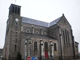
The church of the Transfiguration, in La Chapelle-Saint-Sauveur | ||
| ||
 La Chapelle-Saint-Sauveur | ||
|
Location within Pays de la Loire region  La Chapelle-Saint-Sauveur | ||
| Coordinates: 47°26′31″N 0°59′06″W / 47.4419°N 0.985°WCoordinates: 47°26′31″N 0°59′06″W / 47.4419°N 0.985°W | ||
| Country | France | |
| Region | Pays de la Loire | |
| Department | Loire-Atlantique | |
| Arrondissement | Ancenis | |
| Canton | Ancenis | |
| Intercommunality | Pays d'Ancenis | |
| Government | ||
| • Mayor (2008–2014) | Claude Bricaud (PS) | |
| Area1 | 18.7 km2 (7.2 sq mi) | |
| Population (2006)2 | 727 | |
| • Density | 39/km2 (100/sq mi) | |
| Time zone | CET (UTC+1) | |
| • Summer (DST) | CEST (UTC+2) | |
| INSEE/Postal code | 44034 / 44370 | |
| Elevation | 32–76 m (105–249 ft) | |
| Website |
lachapellesaintsauveur44 | |
|
1 French Land Register data, which excludes lakes, ponds, glaciers > 1 km² (0.386 sq mi or 247 acres) and river estuaries. 2 Population without double counting: residents of multiple communes (e.g., students and military personnel) only counted once. | ||
.svg.png)
La Chapelle-Saint-Sauveur is a former commune in the Loire-Atlantique department in western France. On 1 January 2016, it was merged into the new commune of Loireauxence.[1]
See also
| Wikimedia Commons has media related to La Chapelle-Saint-Sauveur (Loire-Atlantique). |
References
- ↑ Arrêté préfectoral 18 December 2015
This article is issued from Wikipedia - version of the 4/15/2016. The text is available under the Creative Commons Attribution/Share Alike but additional terms may apply for the media files.