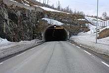
Kvalsund Tunnel
 View of the southern entrance to the tunnel | |
| Overview | |
|---|---|
| Location | Tromsø, Troms, Norway |
| Coordinates | 69°48′48″N 19°00′52″E / 69.8133°N 19.0144°ECoordinates: 69°48′48″N 19°00′52″E / 69.8133°N 19.0144°E |
| Status | In use |
| Route | 863 |
| Start | Kvaløya |
| End | Ringvassøya |
| Operation | |
| Opened | 1988 |
| Character | Automotive |
| Technical | |
| Length | 1,650 metres (5,410 ft) |
| Number of lanes | 2 |
| Lowest elevation | −56 metres (−184 ft) |
| Width | 4.1 metres (13 ft) |
The Kvalsund Tunnel (Norwegian: Kvalsundtunnelen) is a subsea road tunnel which links the islands of Kvaløya and Ringvassøya. Located along Norwegian County Road 863, the tunnel runs under the Kvalsundet strait between the villages of Sørhelltaren and Nordhella. The 1,650-metre (5,410 ft) long tunnel was completed in 1988 and it reaches a depth of −56 metres (−184 ft) below sea level.[1] The tunnel replaced a ferry connection between the islands.
References
- ↑ Merzagora, Eugenio A.; Lotsberg, Gunnar (eds.). "Road Tunnels in Norway 2 000 - 1 000 m". Road Tunnels in Norway. Retrieved 2012-12-09.
External links
 Media related to Kvalsundtunnelen at Wikimedia Commons
This article is issued from Wikipedia - version of the 11/20/2016. The text is available under the Creative Commons Attribution/Share Alike but additional terms may apply for the media files.