Kronotsky Nature Reserve
| Kronotsky Nature Reserve | |
|---|---|
|
IUCN category Ia (strict nature reserve) | |
|
Uzon caldera | |
 | |
| Location | Kamchatka |
| Nearest city |
Petropavlovsk-Kamchatsky (230 km SW) |
| Coordinates | 54°55′31″N 160°32′25″E / 54.92528°N 160.54028°ECoordinates: 54°55′31″N 160°32′25″E / 54.92528°N 160.54028°E |
| Area | 11,421 km² |
| Established | 1882 / 1934 |
Kronotsky (Кроноцкий) Nature Reserve (also: Kronotsky Biosphere Zapovednik) is a nature area reserved for the study of natural sciences in the remote Russian Far East, on the coast of the Kamchatka Peninsula.[1] It was created in 1934 and its current boundary contains an area of 10,990 km2 (4,240 sq mi).[1] It also has Russia's only geyser basin, plus several mountain ranges with numerous volcanoes, both active and extinct. Due to its often harsh climate and its mix of volcanoes and geysers, it is frequently described as the Land of Fire and Ice.[2]
It is mainly accessible only to scientists, plus approximately 3,000 tourists annually who pay a fee equivalent to US$700 to travel by helicopter for a single day's visit.[2] Kronotsky Nature Reserve has been proclaimed a World Heritage Site by UNESCO.[3]
Flora and fauna
Over 750 plant species grow in the reserve, which has volcanoes rising up to a height of over 3,510 m (11,500 feet).[2]
The nature reserve boasts over 800 brown bears, some of the largest in the world that can grow to over 540 kg (1,200 pounds). The 800-plus population make it Eurasia's largest protected brown bear population. Bears in the Kronotsky reserve often encounter each other at salmon streams in the park where they can socialize freely with each other.[4]
Valley of Geysers

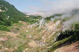
The Valley of Geysers (Russian: Долина гейзеров) is the only geyser field in Eurasia (apart from the Mutnovsky geyser field) and the second largest concentration of geysers in the world. This 6 km long basin with approximately ninety geysers and many hot springs is situated on the Kamchatka Peninsula in the Russian Far East, predominantly on the left bank of the ever-deepening Geysernaya River.
Within the valley a volcanic cone collapsed approximately 40,000 years ago forming the Uzon Caldera, which continues to steam in places where magma can heat groundwater to a near-boil. The area is less than eight miles wide and holds at least 500 geothermal hot springs, mud pots and other similar features.[2]
Among the geysers is the Velikan (giant) Geyser, which erupts with tons of water that shoot more than 25 metres into the air during a minute-long eruption approximately every six hours or so.[2] At least 20 such geysers erupt on a stretch of the Geysernaya River Basin in the Valley of Geysers, along with dozens of smaller gushing vents and hundreds of hot springs. The largest of these geysers erupts with 60 tons of water once or twice a year.[2]
See also
References
- 1 2 Encyclopædia Britannica (2009) Kronotsky Nature Reserve Encyclopædia Britannica, retrieved March 12, 2009, from Encyclopædia Britannica Online
- 1 2 3 4 5 6 Quammen, David (2009) Fragile Russian Wilderness: The Kronotsky Nature Reserve Is Best Appreciated From Afar, National Geographic, p.62, January 2009, Vol. 215, No.1
- ↑ Wild Russia: Centre For Nature Conservation website, retrieved 2009-03-11
- ↑ "Kronotsky Reserve". kronoki.org. Retrieved January 21, 2014.
External links
- Official site of Kronotsky Biosphere Zapovednik (in russian)
- Natural World Heritage -Protected Parks Program: Far Russia
- Kronotsky Biosphere Zapovednik
| Wikimedia Commons has media related to Category:Kronotsky Nature Reserve. |
