Kentucky Route 183
| ||||
|---|---|---|---|---|
| Lock Road | ||||
| Route information | ||||
| Maintained by KYTC | ||||
| Length: | 1.284 mi[1] (2.066 km) | |||
| Existed: | c. 1930s[2] – present | |||
| Major junctions | ||||
| West end: |
| |||
| East end: | Near Green River Lock & Dam #6 | |||
| Location | ||||
| Counties: | Edmonson | |||
| Highway system | ||||
| ||||

Kentucky Route 183 (KY 183), known locally as Lock Road, is a rural, secondary east–west state route located entirely in Edmonson County, Kentucky. This route is 1.284 miles (2.066 km) long. Like some four-digit state highways in rural areas of Kentucky, KY 183 only has one lane.
Route description
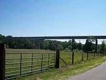
KY 183 begins at an intersection with the concurrent JY 70/KY 259. KY 183 goes under the Green River bridge carrying the other two routes over the river into downtown Brownsville. The end of state maintenance is about a fraction of a mile short of the Green River Lock and Dam Number 6.
KY 183 is designated to be a back road that would link the city of Brownsville to Alexander Cemetery, and the lock and dam, which is operated by the U.S. Army Corps of Engineers. Only a few residences exist in the first half mile of the route. Due to the route being so close to the river, it is often flood prone.
See also
 Kentucky portal
 U.S. Roads portal
References
- ↑ "Official DMI Route Log". Kentucky Transportation Cabinet. Retrieved November 25, 2014.
- ↑ Edmonson County Highway and Transportation Map (PDF) (Map). 1937. Retrieved November 25, 2014.