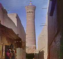
Kalyan minaret

The Kalyan minaret is a minaret of the Po-i-Kalyan mosque complex in Bukhara, Uzbekistan and one of the most prominent landmarks in the city.
The minaret, designed by Bako, was built by the Qarakhanid ruler Mohammad Arslan Khan in 1127 to summon Muslims to prayer five times a day. An earlier tower collapsed before completion. It is made in the form of a circular-pillar baked brick tower, narrowing upwards. It is 45.6 metres (149.61 ft) high (48 metres including the point), of 9 metres (29.53 ft) diameter at the bottom and 6 metres (19.69 ft) overhead.
The body of the minaret is topped by a rotunda with 16 arched fenestrations, from which the muezzins summoned the Muslims in the city to prayer. There is a brick spiral staircase that twists up inside around the pillar to the rotunda. Once the minaret was believed to have had another round section above the rotunda, but now only the cone-shaped top remains. The tower base has narrow ornamental strings belted across it made of bricks which are placed in both straight or diagonal fashion.[1] The frieze is covered with a blue glaze with inscriptions.
In times of war, warriors used the minaret as a watchtower to lookout for enemies.[2]

About a hundred years after its construction, the tower so impressed Genghis Khan that he ordered it to be spared when all around was destroyed by his men.[3] It is also known as the Tower of Death, because until as recently as the early twentieth century criminals were executed by being thrown from the top. Fitzroy Maclean, who made a surreptitious visit to the city in 1938, says in his memoir Eastern Approaches, "For centuries before 1870, and again in the troubled years between 1917 and 1920, men were cast down to their death from the delicately ornamented gallery which crowns it."[4]
References
| Wikimedia Commons has media related to Kalyan minaret. |
- ↑ www.advantour.com/uzbekistan
- ↑ Michell, G. 1995. Architecture of the Islamic World. London: Thames and Hudson, 259
- ↑ Mayhew, Bradley; Clammer, Paul; Kohn, Michael D. Lonely Planet Central Asia. Lonely Planet Publications. ISBN 1-86450-296-7.
- ↑ Maclean, Fitzroy (1949). Eastern Approaches. Jonathan Cape.
Coordinates: 39°46′32.44″N 64°24′54.04″E / 39.7756778°N 64.4150111°E