Jupa Tawqaña
| Jupa Tawqaña | |
|---|---|
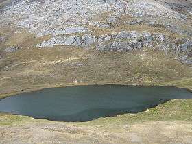 Yanaqucha ("black lake") at the foot of Jupa Tawqaña | |
| Highest point | |
| Elevation | 4,800 m (15,700 ft) [1] |
| Coordinates | 09°59′01″S 77°03′17″W / 9.98361°S 77.05472°WCoordinates: 09°59′01″S 77°03′17″W / 9.98361°S 77.05472°W |
| Geography | |
 Jupa Tawqaña Peru | |
| Location | Peru, Ancash Region |
| Parent range | Andes, Wallanka |
Jupa Tawqaña (Aymara jupa quinoa, tawqaña to pile,[2] "where quinoa is piled", hispanicized spelling Jupaytaugana) or Jupa Tawqana (Quechua tawqa heap, pile, -na a suffix)[3] is a mountain in the Wallanka mountain range in the Andes of Peru which reaches an altitude of approximately 4,800 m (15,700 ft). It is located in the Ancash Region, Bolognesi Province, Aquia District. Jupay Tawqaña lies at the Kinwa Raqra valley (Quechua kinwa quinoa, raqra crack, crevice, "quinoa crack", hispanicized Quennua Ragra) northeast of Kinwa Quta ("quinoa lake", hispanicized Genhuacuta).[1]
References
- 1 2 escale.minedu.gob.pe - UGEL map of the Bolognesi Province (Ancash Region)
- ↑ Radio San Gabriel, "Instituto Radiofonico de Promoción Aymara" (IRPA) 1993, Republicado por Instituto de las Lenguas y Literaturas Andinas-Amazónicas (ILLLA-A) 2011, Transcripción del Vocabulario de la Lengua Aymara, P. Ludovico Bertonio 1612 (Spanish-Aymara-Aymara-Spanish dictionary)
- ↑ Teofilo Laime Ajacopa, Diccionario Bilingüe Iskay simipi yuyayk'ancha, La Paz, 2007 (Quechua-Spanish dictionary)
This article is issued from Wikipedia - version of the 12/15/2015. The text is available under the Creative Commons Attribution/Share Alike but additional terms may apply for the media files.