Juan Aldama, Zacatecas

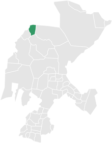
Location of Juan Aldama (municipality) in Zacatecas
Juan Aldama is a city in the northwestern portion of the Mexican state of Zacatecas. It is the biggest community in the Municipality of Juan Aldama and the seat of the municipal government.
It was renamed for insurgent Juan Aldama. It had previously been known as San Juan Bautista del Mezquital and Villa Aréchiga.
Juan Aldama is surrounded by small towns such as Ojitos, Jalpa, Cienega, and many others.
Population
- Population: about 18,000.
- Death rate: 50 people yearly.
- Newborn rate: 200 babies yearly.
Climate
| Climate data for Juan Aldama (1951–2010) | |||||||||||||
|---|---|---|---|---|---|---|---|---|---|---|---|---|---|
| Month | Jan | Feb | Mar | Apr | May | Jun | Jul | Aug | Sep | Oct | Nov | Dec | Year |
| Record high °C (°F) | 30.0 (86) |
30.5 (86.9) |
36.0 (96.8) |
37.0 (98.6) |
39.0 (102.2) |
39.5 (103.1) |
39.0 (102.2) |
35.0 (95) |
35.0 (95) |
37.0 (98.6) |
31.0 (87.8) |
31.0 (87.8) |
39.5 (103.1) |
| Average high °C (°F) | 20.6 (69.1) |
22.5 (72.5) |
26.0 (78.8) |
29.2 (84.6) |
31.6 (88.9) |
31.6 (88.9) |
28.9 (84) |
28.1 (82.6) |
26.5 (79.7) |
25.6 (78.1) |
23.6 (74.5) |
21.1 (70) |
26.3 (79.3) |
| Daily mean °C (°F) | 12.3 (54.1) |
13.6 (56.5) |
16.5 (61.7) |
19.6 (67.3) |
22.3 (72.1) |
23.3 (73.9) |
21.8 (71.2) |
21.3 (70.3) |
19.8 (67.6) |
17.8 (64) |
15.2 (59.4) |
13.0 (55.4) |
18.0 (64.4) |
| Average low °C (°F) | 4.0 (39.2) |
4.7 (40.5) |
7.1 (44.8) |
10.0 (50) |
13.0 (55.4) |
15.1 (59.2) |
14.7 (58.5) |
14.4 (57.9) |
13.1 (55.6) |
10.0 (50) |
6.8 (44.2) |
4.9 (40.8) |
9.8 (49.6) |
| Record low °C (°F) | −7.5 (18.5) |
−10.0 (14) |
−4.5 (23.9) |
−2.0 (28.4) |
5.0 (41) |
9.5 (49.1) |
6.0 (42.8) |
2.5 (36.5) |
4.0 (39.2) |
−3.5 (25.7) |
−5.0 (23) |
−14.0 (6.8) |
−14.0 (6.8) |
| Average precipitation mm (inches) | 7.2 (0.283) |
7.1 (0.28) |
2.7 (0.106) |
3.8 (0.15) |
12.3 (0.484) |
58.3 (2.295) |
91.9 (3.618) |
110.9 (4.366) |
88.6 (3.488) |
27.6 (1.087) |
10.9 (0.429) |
9.8 (0.386) |
431.1 (16.972) |
| Average precipitation days (≥ 0.1 mm) | 1.3 | 1.2 | 0.5 | 0.9 | 1.8 | 6.1 | 9.0 | 10.6 | 8.2 | 3.5 | 1.3 | 1.3 | 45.7 |
| Source: Servicio Meteorologico Nacional[1][2] | |||||||||||||
Economy
- Technology/Communication/Media: Internet, Telephone, and Fax.
- Juan Aldama's main source of economy is based on trade and cultivation of corn and beans.
Entertainment
Juan Aldama's center of entertainment is Minarturs discothèque and the Alameda located at the south side of the main plaza.
References
- ↑ "Estado de Zacatecas-Estacion: Juan Aldama". Normales Climatologicas 1951–2010 (in Spanish). Servicio Meteorologico Nacional. Retrieved 20 April 2015.
- ↑ "Extreme Temperatures and Precipitation for Juan Aldama 1964–2011" (in Spanish). Servicio Meteorológico Nacional. Retrieved 20 April 2015.
External links
Coordinates: 24°17′28″N 103°23′38″W / 24.291°N 103.394°W
This article is issued from Wikipedia - version of the 7/17/2015. The text is available under the Creative Commons Attribution/Share Alike but additional terms may apply for the media files.